|
Author
|
Topic: NT1?
|
dleedvm
|
 posted October 09, 2011 06:29 AM


Hi everyone,
In the High Seas Discussion is the following:
SEAS AT 12Z WERE 2 TO 5 FT
OVER NT1 AND NW NT2
What are NT1 and NT2? Thanks
David
|
|
David Burch
|
posted October 09, 2011 08:11 AM
These discussions are famous for terse Abbreviations. I will look it up. We have a list somewhere. First guess is night 1 and night 2.... But there is no dire tion on nt1. Is this the full quote?
From: Starpath, Seattle, WA
|
|
David Burch
|
posted October 09, 2011 08:32 AM
Here is the list i was thinking of and it is not on it
http://www.opc.ncep.noaa.gov/Glossary.shtml
So we need to know more of the source? Is this a recent one and if so do you have all of it.... Or if from our materials pls tell me where
Thanks.
--david
From: Starpath, Seattle, WA
|
|
dleedvm
|
posted October 09, 2011 07:39 PM
Here is the full discussion. It is the current high seas discussion for the Atlantic. Thanks
David
AGNT40 KWNM 081351
MIMATN
MARINE WEATHER DISCUSSION
NWS OCEAN PREDICTION CENTER WASHINGTON DC
930 AM EDT SAT 8 OCT 2011
.FORECAST DISCUSSION: MAJOR FEATURES/WINDS/SEAS/SIGNIFICANT
.WEATHER FOR THE NORTH ATLANTIC OCEAN W OF 50W FROM 30N TO 50N.
DOING EXTRATROPICAL FORECAST POINTS FOR T.S. PHILIPPE SO WILL BE
BRIEF.
A HIGH PRES CENTER OVER THE MID ATL REGION DOMINATED THE
OFFSHORE WATERS THIS MORNING. WINDS OVER THE AREA WERE W 10 TO
15 KT OVER NT1...N TO NW 10 TO 15 KT N OF BALTIMORE CANYON OVER
NT2...N TO NE 15 TO 20 KT FROM BALTIMORE CANYON TO CAPE FEAR AND
NE 15 TO 25 KT S OF CAPE FEAR TO 31N. SEAS AT 12Z WERE 2 TO 5 FT
OVER NT1 AND NW NT2 AND 5 TO 12 FT OVER SE NT2 WITH THE HIGHEST
IN THE FAR S WATERS.
HIGH PRES WILL DOMINATE THE AREA INTO MON WITH A LOW PRES TROUGH
DEVELOPING S OF THE AREA. A STRONG GRADIENT WILL DEVELOP BETWEEN
THE STNRY HIGH AND THE TROUGH TO THE S. FOR THE UPDATE WILL KEEP
30 KT ACROSS THE WATERS S OF HATTERAS CANYON TODAY INTO TNGT BUT
PLAN TO INC TO GALE FORCE SUN INTO MON AS THE TROUGH MOVES FROM
E TO W FROM THE BAHAMAS INTO FLORIDA. THE ECMWF IS SLIGHTLY
WEAKER THEN THE GFS BUT MOST MODELS ARE SHOWING GALE FORCE WINDS
S OF CAPE FEAR. THE GFS 30M WINDS FOR UNSTABLE CONDITIONS HAVE A
LARGE AREA OF WINDS AT 30 KT. FOR NOW WILL START GALE SUN BUT
MAY HAVE TO GO WITH LATE TONIGHT WITH NEXT PACKAGE. FOR SEAS THE
WAVE WATCH III LOOKS GOOD S OF CAPE HATTERAS...THE ECMWF WAVE
MODEL IS 1-2 FT LOW. NO OTHER CHANGES FOR UPDATE.
---------------------------------------------------------------
PREVIOUS DISCUSSION
OVER THE SHORT TERM...THE NEW 00Z FCST MDLS GRNLY AGREE THAT THE
CSTL/OFSHR WTRS WL CONT TO BE DOMINATED BY A STRONG HIGH PRES
CENTER RMNG QSTNRY INVOF THE NRN MID ATLC COAST. AS WAS DONE
PREVLY PLAN ON FAVORING THE SLIGHTLY WEAKER ENELY GRADIENT FCST
BY THE 00Z UKMET/12Z ECMWF ACRS THE SRN NT2 WTRS WITH MAX ASCD
WINDS UP TO 25 OR 30 KT. SO NO SIG SHORT TERM CHNGS ARE PLANNED
TO THE PREV OFSHR FCSTS.
IN THE LONG RANGE...THE PATTERN GETS MR COMPLICATED AS THE MDLS
DIFFER ON THE FCST TRACK OF A SFC LOW TRACKING NWD INVOF FLORIDA
MON/TUE AND THEN NEWD INTO THE NT2 WTRS WED. THO SLIGHTLY SLOWER
THAN ITS PREV 18Z RUN...THE 00Z GFS CONTS TO TRACK ITS SFC LOW E
OF FLORIDA MON...INTO THE FAR SW NT2 WTRS TUE...THEN NEWD ACRS
THE CNTRL/NRN NT2 WTRS WED WITH GALE FORCE ASCD BL WINDS
SPREADING NWD INTO THE SRN NT1 BY LATE WED. THE 00Z GEFS MEAN
GNRLY SPRTS THE 00Z GFS FCST TRACK MON/TUE...BUT THEN INDICATES
THAT THE ITS FCST PSN IS TOO FAR NE ON WED. THE 00Z UKMET FCSTS
A SLOWER AND MORE SUPPRESSED SOLUTION CLOSER TO THE OLD 12Z
ECMWF AND HPC MEDIUM RANGE GUIDANCE. THE 00Z CANADIAN GLOBAL GEM
LOOKS LIKE A FAST OUTLIER. WL WAIT TO SEE THE 00Z ECMWF BEFORE
MAKING A FINAL DECISION...BUT AT THE MOMENT PLAN ON FAVORING A
BLENDED 00Z GEFS MEAN/12Z ECMWF SOLUTION FOR THIS SYSTEM. PER
THE LATEST MDLS ASCD GALES ARE CERTAINLY LOOKING PSBL ACRS THE
SRN NT2 WTRS. BUT FOR NOW (UNLESS THE 00Z ECMWF LATER DICTATES
OTHERWISE) DUE TO THE LARGE DISPARITY BTWN THE MDLS WL CONT TO
HOLD OFF ON FCSTG ANY PSBL GALES. SO OVERALL NO MAJOR LONG RANGE
CHNGS ARE PLANNED TO THE PREV OFSHR FCST PACKAGE.
SEAS...OVERALL THE 00Z WAVEWATCH III FCST SEAS LOOK
REPRESENTATIVE OVER THE SHORT TERM. BUT IN THE LONG RANGE...AS
WAS DONE FOR THE PREV OFSHR FCST PACKAGE...WL LIKELY FAVOR THE
MORE CONSERVATIVE ECMWF WAM FCST SEAS.
EXTRATROPICAL STORM SURGE GUIDANCE...THE 00Z ETSS MODEL ON MON
FCSTS SURGE VALUES INCRS TO GNRLY THE 1.0 TO 2.0 FT RANGE ALONG
THE COAST BTWN CP FEAR AND ST AUGUSTINE WHICH ARE LIKELY
OVERDONE SINCE THE STRONGER 00Z GFS SOLUTION WL NOT BE FAVORED.
.WARNINGS/FORECAST CONFIDENCE...PRELIMINARY. ANY CHANGES WILL BE
COORDINATED THROUGH AWIPS 12 PLANET CHAT OR BY TELEPHONE:
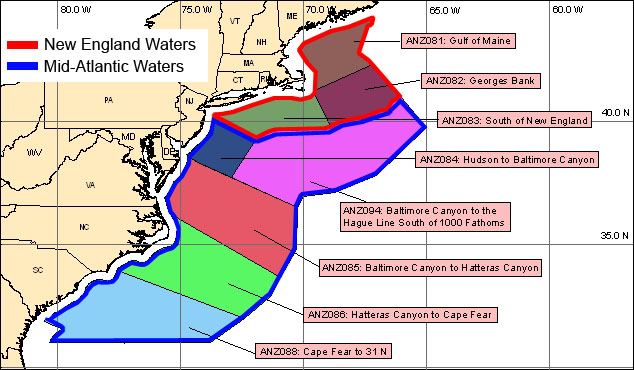
.NT1 NEW ENGLAND WATERS
.GULF OF MAINE...NONE.
.GEORGES BANK...NONE.
.S OF NEW ENGLAND...NONE.
.NT2 MID ATLC WATERS
.HUDSON TO BALT CNYN...NONE.
.BALT CNYN TO HAGUE LINE...NONE.
.BALT CNYN TO HATTERAS CNYN...NONE.
.HATTERAS CNYN TO CAPE FEAR...NONE.
.CAPE FEAR TO 31N...GALE...SUN...MOD CONFC.
.FORECASTER OSZAJCA/VUKITS. OCEAN FORECAST BRANCH.
|
|
Ferrel
|
posted October 10, 2011 07:59 PM
we have answers on this.... but are having technical trouble posting. more later. in short, these are weather regions, but there is more to explain.
NT1 = NEW ENGLAND WATERS
NT2 = MID ATLC WATERS
will explain tomorrow when we get the posting issue resolved.
|
|
David Burch
|
posted October 10, 2011 08:10 PM
The term NT1 and NT2 refers to all New England waters or all the Mid Atlantic waters, respectively.
I have written to NOAA to ask where we might have learned that since this is not in any list that i can find.
we have the sub regions named individually at
http://www.nws.noaa.gov/om/marine/zone/wrdoffmz.htm
and they are on the MSC, but i do not yet find these definitions for the full regions. ie the NT1 and NT2 are the full larger regions made up of numerous smaller regions.
From: Starpath, Seattle, WA
|
|
David Burch
|
posted October 15, 2011 01:29 PM
We have updated Weather Trainer Live to include the list of discussion abbreviations. There is a link to it on the Glossary page.
From: Starpath, Seattle, WA
|
|
David Burch
|
posted October 27, 2011 03:18 PM
Strangely enough we could not find any official definitions of New England Waters and of Mid Atlantic Waters, but reading between the lines on several web pages we have come up with the definition shown in the attached pic. Note we made this, this is not official NWS and we in fact cannot get confirmation from anyone at NWS that this is right or wrong.
From: Starpath, Seattle, WA
|
|