This is topic Universal Plotting Sheet Setup Instructions (An Alternate Method) in forum Public Discussion of Cel Nav at Online Classroom.
To visit this topic, use this URL:
https://www.starpath.com/cgi-bin/ubb/ultimatebb.cgi?ubb=get_topic;f=16;t=000062
Posted by Gary Rose (Member # 504) on March 30, 2005, 05:35 PM:
I recently purchased some universal plotting sheets from Celestaire and they came with some interesting instructions for setting up the form. Steps 3 and 5 are what I found the most interesting. These universal plotting sheets have the longitude scale on them.
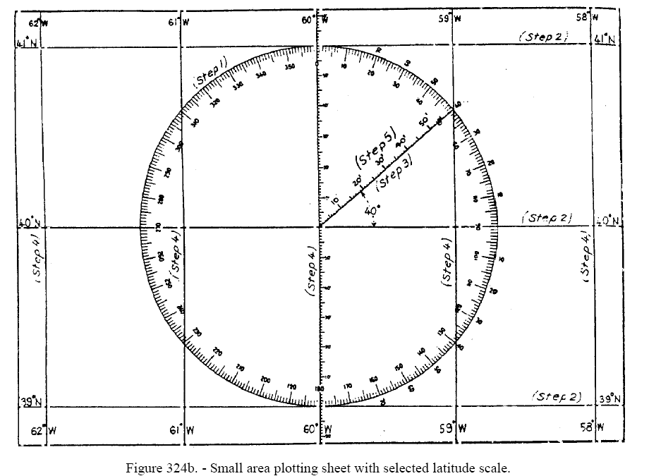
Step one At the center of the sheet draw a circle with a radius equal to 1° (or any other convenient unit) of latitude at the desired ale. If a sheet with a compass rose is available, as in figure 324b [link to plot sheets] the compass rose can be used as the circle and will prove useful for measuring directions. It need not limit the scale of the chart, an additional concentric circle can be drawn and desired graduations extended to it.
Step two. Draw horizontal line, through the center of the circle and tangent at the top and bottom. These are parallels of latitude; label them accordingly, at the selected interval (as every 1° 30, etc.).
Step three. Through the center of the circle draw a line making an angle with the horizontal equal to the mid-latitude. In figure 324b [link to plot sheets] this angle is 40°.
Step four. Draw in and label the meridians. The first is a vertical line through the center of the circle. The second is a vertical line through the intersection of the oblique line and the circle. Additional meridians are drawn the same distance apart as the first two.
Step five. Graduate the oblique line into convenient units. If 1 is selected, this scale serves as a latitude and mile scale. It can also be used as a longitude scale by measuring horizontally from a meridian instead of obliquely along the line.
Posted by Starpath (Member # 1) on March 31, 2005, 11:01 AM:
Below is the figure you sent me from this set of instructions:
This picture and the instructions that come with it that you said were provided as instructions to the universal plotting sheets (if i understand correctly), is actually reproduced from an early version of Bowditch, see p88 of the green 1977 edition.
I would guess that this figure and instructions have nothing to do with the purchased (preprinted)Universal plotting sheets themselves, but is rather a set of instructions on how to make universal plotting sheets from scratch.
There appears to be some mixup on the intention of the seller for including these instructions with the preprinted forms, which have their own set of instructions that we are familar with and have been using in the course. It was likely just a bonus set of notes on how to make new ones if you run out of the printed ones.
-------------
Note we do cover how to make these sheets ourselves in some part of the course materials, and note that we do have hi-res plotting sheets like these that you can download to print for yourself as needed.
Posted by Gary Rose (Member # 504) on March 31, 2005, 02:50 PM:
When I scaned in the page of instructions I somehow missed the top line.
"INSTRUCTIONS FOR VP-OS SHEETS"
Gary
Posted by Starpath (Member # 1) on March 31, 2005, 05:06 PM:
Well, that makes things a little bit worse, since "VP-OS SHEETS" is indeed the official name of the Universal Plotting Sheets and these are, as explained, NOT the instructions for using universal plotting sheets, they are the instructions for making sheets from scratch. Must be a typo in the presentation.
On the other hand, this points out the good value of having an online cel nav course where such issues can be addressed.
Copyright, 2003-2021, Starpath Corporation
Powered by Infopop Corporation
UBB.classicTM
6.3.1.1