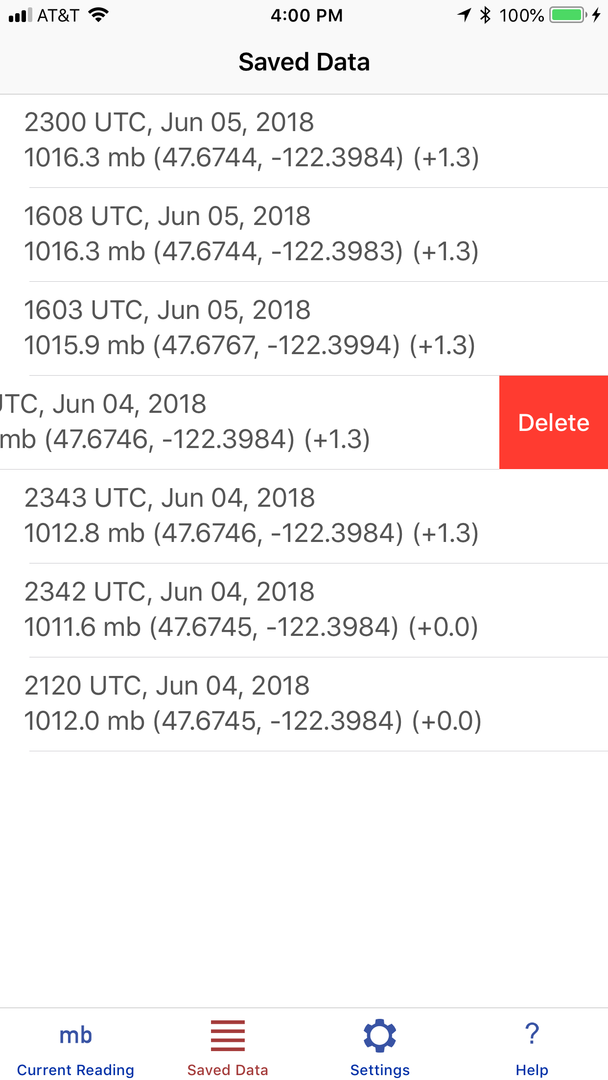
The Captain who watches his barometer, watches his ship. Marine Barometer is a barometer sensor interface that is uniquely designed to meet the needs of mariners who rely on accurate atmospheric pressure for weather routing and the evaluation of weather maps. Pressure readings can be manually saved permanently along with the latitude, longitude, and time of the reading. If a sensor offset has been applied, that value is also stored with each recorded pressure. These recorded pressures can then at the navigator's convenience be transferred to the vessel's printed logbook.
Full copy of the included Help file
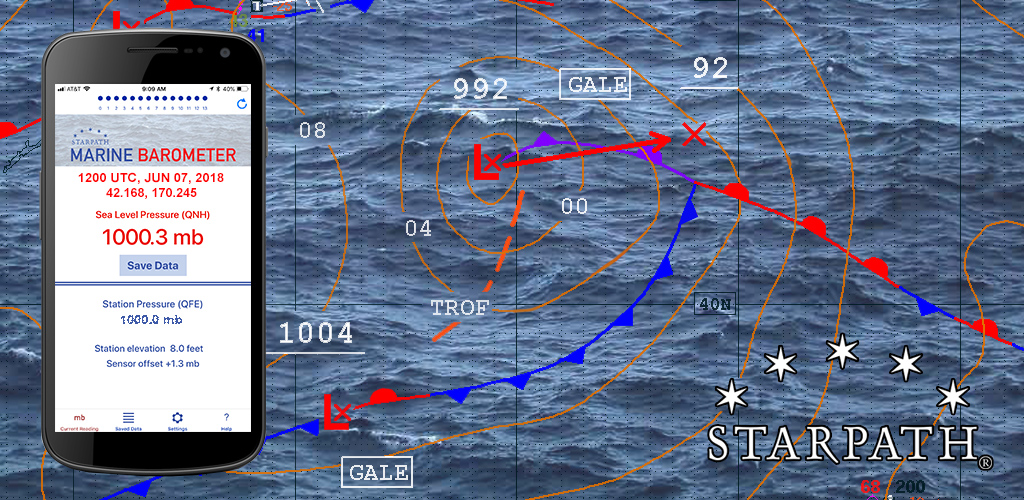
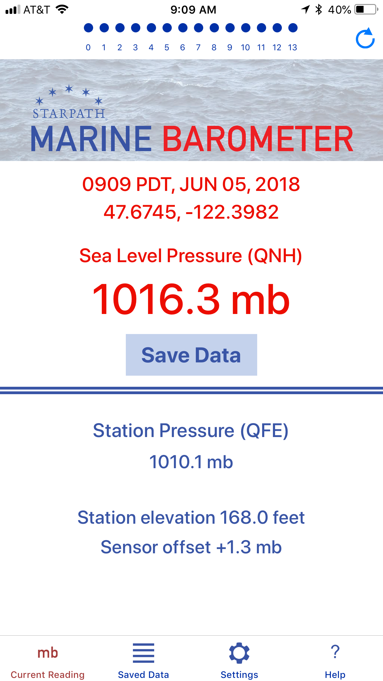
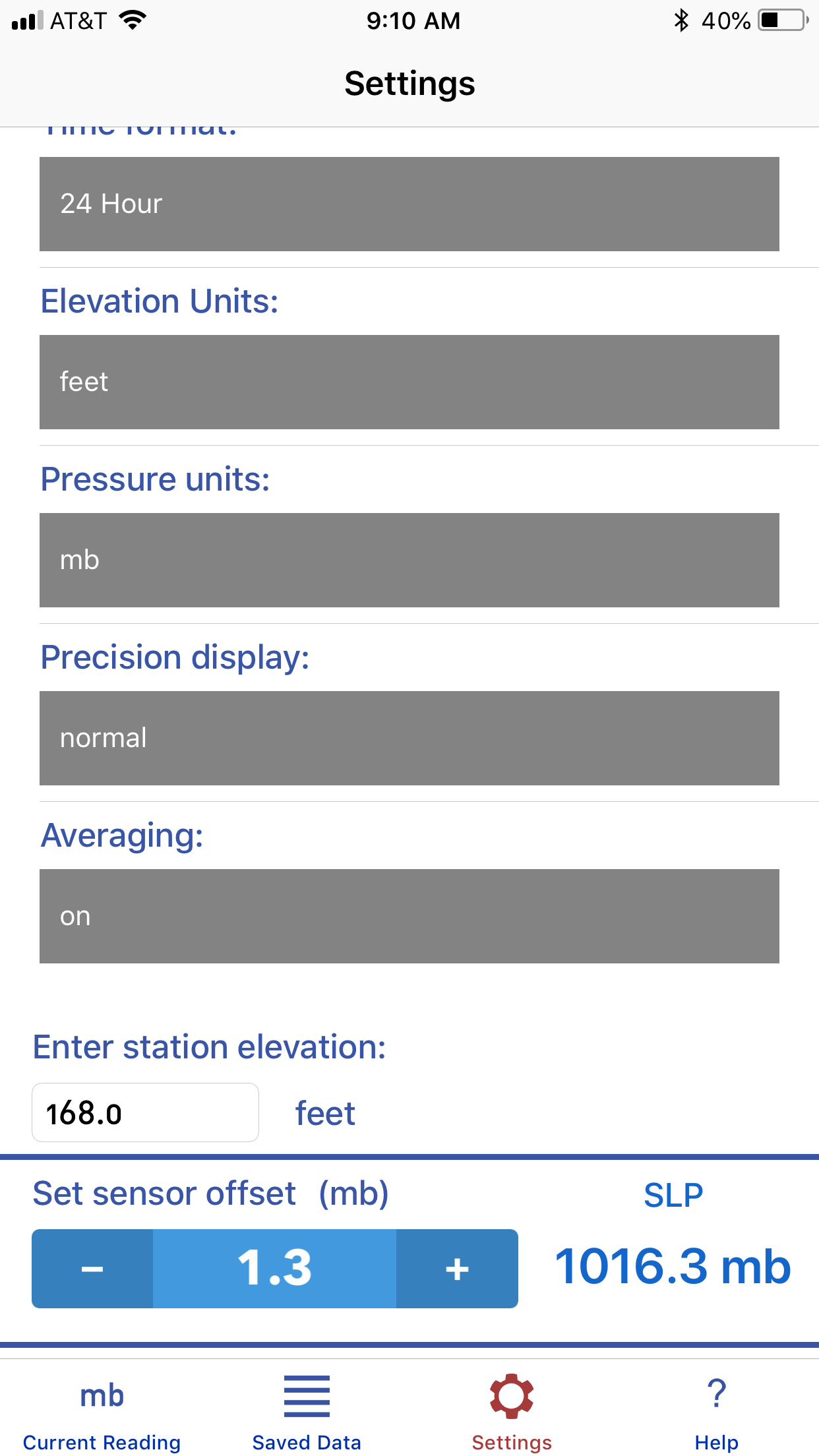
BACKGROUND CAUTION However, even set properly, they are not intended to replace a trusted precision aneroid barometer for use at sea. All electronics are vulnerable to the rigors of the maritime environment and to a dependable source of power. An electronic barometer is to a trusted aneroid much the same as the GPS is to a trusted sextant. We use it at our convenience, but we are not dependent on it. DEFINITIONS Standard units of pressure for maritime use are millibars (mb) or the equivalent hectoPascals (hPa). All marine weather forecasts and weather maps internationally use these units, which are the World Meteorological Organization (WMO) standards. Aviation and U.S. "TV weather" use inches of mercury (inHg), and science labs and European barometers generally use millimeters of mercury (mmHg), which are also called Torr. Q-codes are 3-letter abbreviations originally developed for telegraph messages, i.e., QSL means "message received." Many of these have lingered into modern times as they can serve to clarify communications. Barometer usage employs three of these: QFE, QNH, and QFF, as described below. Sensor pressure is the raw output from your device's pressure sensor. This app allows you to apply a sensor offset to that value as needed. Station pressure (QFE) is the sensor pressure corrected for sensor offset, if any has been entered in the Settings. Station pressure is the atmospheric pressure at the location (position and elevation) of the device at the time it is read. This pressure will always be lower than sea level pressure, unless your phone is floating on the sea surface. How much lower, depends primarily on how high you are above sea level (station elevation.) Sea level pressure (QNH) is the atmospheric pressure at your location that would be measured at sea level at that moment and place. (If you were on land on a hill 100 ft high, it would be the pressure your barometer would read at the bottom of a 100-ft deep hole.) It is the station pressure increased to account for your elevation above sea level (station elevation), assuming the atmosphere is adequately described by the International Standard Atmosphere. This is a good approximation, and this pressure (QNH) is the working value of sea level pressure used in marine navigation. Strictly speaking, there are other small corrections besides the elevation that contribute to the true sea level pressure shown on weather maps (QFF), but outside of extreme temperatures and high elevations, we can use QNH as our value for sea level pressure. Aviation weather forecasts call QNH the altimeter setting. Sea Level Pressure (QFF) is the sea level pressure shown on weather maps and given in forecasts. For essentially all practical applications at sea we can approximate this adequately with QNH by correcting station pressure for elevation alone. In extreme temperature conditions from a high deck of a ship, there could be additional corrections approaching ±0.5 mb. Sea Level Pressure (SLP) is the generic name and abbreviation of sea level pressure used when the above distinctions are not being made, which is indeed most of the time in marine applications. The abbreviation MSLP shown on some weather maps refers to the pressure at the mean sea level, because the sea level is always rising and falling to some extent. In essentially all contexts, SLP is the same as MSLP. Latitude and Longitude are presented as decimal degrees. N Lat and E Lon are positive; S Lat and W Lon are negative. USE OF THE APP To save battery power, hide the app (home button) or close it after reading and saving the pressure. To further save power, this app reads the GPS only as needed, and not continuously. SAVE DATA This app can also be used to temporarily store waypoints, even if the pressure is not needed. Just turn it on and Save Data to record your position and time in the data table. SETTINGS Time format: Marine weather and navigation uses a 24 hour clock, i.e., 1330 rather than 12-hr time, 1:30 PM. Elevation units: Feet or meters. This is a user preference; strangely, the U.S. National Weather Service uses both, as do NOAA charts. Other maritime nations use only meters. Pressure units: Millibars (mb) or hectoPascals (hPa) are used in marine weather, universally. Precision display: In this app, normal precision refers to one decimal place, corresponding to the marine weather standard, i.e., 1013.3 mb. High precision is two decimal places; low precision is no decimals. Weather maps typically show isobar spacings of 4 mb. Ship and buoy reports are given in normal precision. Averaging: Turns the 14-second sliding average on or off. When turned on the main page shows the average accumulating with a progression of red dots. When only 5 dots are showing, it means the average is only over the past 5 seconds. Once the full line of dots are red, there is an ongoing 14-second average being applied. If for any reason you wish to restart the averaging, press the restart button at the top right of the screen. Station elevation: This is the height of the barometer above mean sea level (MSL). In the ocean, this can be considered height above the waterline (H): station elevation = H. In tidal waters, we have to account for the tide height (T). So station elevation = H + T - MSL, where MSL = (MHW + MLW)/2. For examples and illustrations see books listed in the References below. On land, you can get the elevation of the ground at your location from Google Earth or from starpath.com/barometers based on your Lat-Lon. Then we need the height of the barometer above the ground (called the removal), or station elevation = ground elevation + removal. For examples and illustrations see books listed in the References below. Sensor offset: This is a correction to apply when you believe that the device sensor itself is not precisely correct. It should only be applied when you have good reason to question the sensor reading, which (considering the typical accuracy of the sensors) is not easy to determine unless your device is sitting next to another barometer that is certified correct. When you compare pressures with a friend's device, side by side, and they do not agree, then at least one of them needs a sensor offset. This offset would typically be less than a few millibars. Without a certified comparison barometer, we have to determine the correct station pressure at our station elevation based on official reports of sea level pressure (SLP), discussed below. Official reports are always given as SLP. Once we have an accurate SLP for our location at a specific time, we need to know the accurate station elevation (see above), and if the times are not the same, we need to account for the rate of change in the pressure between reference time and present time. Books referenced below give detailed examples of this process. NOAA's primary references and weather maps provide the pressure in mb, which is the unit we use to set the offset, regardless of other units chosen for display. After entering the correct station elevation for your device and determining the correct SLP in mb at the moment at your location, press the ± keys until the displayed pressure beside the keys matches that pressure. Then return to the main page and save the data. This records the time and pressure you used when changing the offset. The sensor offset is stored until you change it again. The stored offset is recorded with each stored pressure record. Determination of an accurate offset is typically an iterative process of making your best estimate once, and then checking it periodically at various pressures. RESOURCES
Copyright © 2018, Starpath Corporation |