6-19. Reworded: 6-19. It is pea soup fog, but from a brief break in visibility you spot the white light on the Hein Bank Buoy north of you, at an estimated distance off of 1 to 3 nmi. Then it socks in again. Your speed is 6 kts and your course is 110 T. Shortly after that you noticed that your depth sounder dropped from something like 20 fathoms to 70 within a few minutes. This gives you the idea to look at the contours on the chart to see if you can figure out where you are from a line of soundings measurement as you cross the Eastern Bank, which you believe is somewhere ahead of you. Looking at the chart, you decide to concentrate on 20-fm and 50-fm contours
You confirm there is no forecasted currents expected at this time. The tide height and the sounder draft have been accounted for, so the recorded depths in the table below are the expected charted depths. (This measurement is best done with log readings rather than just times, because it will expedite the analysis. If you are running in a DR mode, assuming GPS has failed, then you can also drop a DR mark at each sounding record that will further simplify the analysis.)
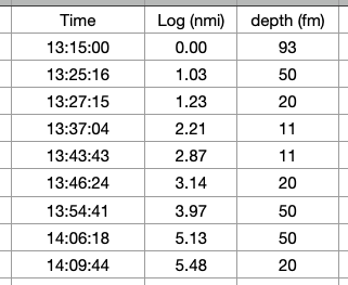
Part A, what is your estimated Lat-Lon at 14:09:44?
Other parts and solutions remain the same.
3-11 (b) should be 4.2 not 3.8.
More indepth answer to 3-10:
3-10. (A) Geo. Range = 1.17 x [ SQRT(9) + SQRT(118)] = 16.2 nmi, Nom. Range = 15 nmi on the paper chart (or RNC of it), and 19 nmi according to the Light List. Usually the LL will be the newest information so we use 19 nmi as the Nominal range, which means the light is bright enough to show over the full geo range, but the geo range is the limiting factor. Answer is Visual Range = 16.2 nmi.
Light List data for Race Rocks and New Dungeness are missing in the workbook. Here are the data

(B) Geo. Range = 1.17 x [ SQRT(9) + SQRT(67)] = 13.1 nmi, Nom. Range = 22 nmi, therefore Visual Range = 13.1 nmi.
![]()
(C) No! New Dungeness Lt. is charted 4 nmi brighter than the Light List, and Race Rocks light is charted 4 nmi dimmer than the Light List. We have to assume that the Light List data are more accurate as they are updated weekly. Using electronic navigational charts (ENC) on the other hand, we would find these two sets of data stay in sync as both are updated weekly. Remember, too, that we are using a training chart locked into 1998. The present charted values of these lights match the Light List data.
Clarification of answers to 3-15, 3-16, 3-17 and 3-20
3-15. Clarify source: 9 ft, see paragraph [CP 193] in the Coast Pilot
3-16. You are “bobbing the light” which means you are at about the geographic range. So we look at the geo range from both observation heights. The Pt Wilson light is at 51 ft. Cabin top: Geo range = 1.17 x [SQRT(51) + SQRT(15)] = 12.9 nmi. From the cockpit: Geo range = 1.17 x [SQRT(51) + SQRT(8)] = 11.7 nmi. So the light is more than 11.7 nmi off but less than 12.9 . This technique works best for lights that are bright and low, i.e., for ones with a geographic range that is smaller than its nominal range - the more smaller, the more better.
3-17. (A) In clear weather this is limited by its height which is about 200 feet (see Coast Pilot), so 1.17 x [SQRT(200) + SQRT (9)] = 20.0 miles, which would be a theoretical value for the tip to be just on the horizon... But the reality is you would not see it (unlit) from that far off. This is in part why we encourage dropping the 1.17 factor for these reckonings (leaving here about 17 nmi), but to be geometrically correct it would be the 20 nmi... The parenthetical answer given, however, is probably close, i.e., about 15 with binoculars. But this would have to be clear weather.
3-19. adjust the geo range comments to "...to geographic range of about 1.17x[sqrt(9) + sqrt(12)] = 7.6,"
which shows that it is the light brightness that is usually the..."
3-20. You are “bobbing the light” (see 3-16) which means you are at about the geographic range. So we look at the geo range from both observation heights. The light in view is at 27 ft. Cabin top: Geo range = 1.17 x [SQRT(27) + SQRT(12)] = 10.1 nmi. From the cockpit: Geo range = 1.17 x [SQRT(27) + SQRT(7)] = 9.2 nmi. So the light is more than 9.2 nmi off but less than 10.1.
Problem 4-12 Question:
Following US Shore Route of problem 2-30 in reverse to the west (WP4 to WP1), select appropriate points (A, B, C) along each leg that would mark the approximate halfway point of the leg and identify a magnetic bearing at those points that would mark that location. Point A is between WP 4 and WP3, B is between WP3 and WP2, and C is between WP2 and WP1. Choose a landmark that is near the beam at each location. Give the name of the mark, the bearing to it, and briefly outline your reasoning for choosing it over others that might be possible. You can use the Coast Pilot to help with descriptions of the landmarks. You might also find it interesting to follow this route in Google Earth looking at the terrain. Also note, this exercise is tied to an earlier one so we kept the same waypoint numbers, but it is generally valuable to have your numbers increase along a route.
Problem 4-12 Answer:
(A) WP4 to WP3 offers several options affirming your half-way point. Just before halfway on this leg, the tank on Protection Island aligns with the AERO light on Diamond Pt, bearing 164M. Either of these alone would be useful landmarks. A natural range, bearing 146M, runs between the tip of Violet and Beckett Points right at the mid point. You’re in 13 fathoms of water just north of the Dallas Bank—a good way to know you are not on the bank.
(B ) The halfway mark from WP3-WP2 is 7.6 miles along that leg. Not so much onshore to rely on. Slightly past halfway, an unnamed point aligns with Lost Mt, bearing 139M. Green Pt. will be slightly ahead, bearing 163M. The Coast Pilot lacks details for this section. The western most "stack" at the foot of a small dock bears 214M. Remember you can check your depth here as well. You are inside or near a depth area of 27 to 30 fathoms.
(C) At 5.1 miles, (halfway between WP2 and WP1 the tower at Angeles Pt. bears 103 M, the tower west of Observatory Pt. bears 227 M. The mouth of Colville Creek is about 2 miles off, bearing 174M, which should be discernible as it forms a notable valley in the elevation contours.
Answer to new 9-1, Set 080° T, Drift 1.0 kts . See https://youtu.be/XRuZY8miOPo
CTS = 035.2 T, Var= 020 E, CTS = 015.2 M, Dev = 2.5 E, CTS= 012.7 C.