Errata for
Navigation Workbook 18465 Tr
, 2nd printing
Page |
Change |
| 3. | 2-20 and 2-21. The Pacific Coast Chart Catalog is no longer referred to as "No.2." When these switched to online PDFs only, they removed the numbering system. |
| 3. | 2-8. We expanded the wording for exercise 2-8. Same route now reads: 2-8. Trace out this route and figure the total distance around it taking all marks to port: Start at Buoy S (north of Dungeness Spit), then travel to Buoy 1 at west end of Protection Island, then on around the south side to east end of Protection Island, then NE to Buoy SA, and from there to Minor Island Light, and then to Hein Bank Buoy DH, and on to Buoy R, and then back to Buoy S. |
| 13. | Add to the introduction that appears in italics this note: We do several piloting exercises using buoys, but we stress that this is primarily for convenient practice. Underway we should avoid using buoys whenever possible as their charted positions may not be correct. |
13. |
Italicized note should read "problems 6-3 through 6-6." |
13. |
In problem 6-4 the two references to 5-1 should refer to 6-3. |
14. |
In problem 6-6 the reference to 5-3 should refer to 6-5. In problem 6-17, the reference to 5-14 should refer to 6-16 |
| 14. | In problem 6-17, change "...assume there is in addition a strong northerly wind..." to "...assume there is in addition a fresh wind from 040T..." Thanks to reader Michael Donatz for pointing out the need for this correction. |
| 19. | Problem 9-1 and its answer. On the question, reword to note that this can also be worked on using chart 18429 which is a free echart. Then also reword to note that we only need to find the course to steer if the currents are notable. On the first two legs the currents are too small to bother with. See also new solution notes below for page 94. |
| 34. | 12-14 (F) Change "current" to "leeway." |
| 54. | We have made a new sample Light List page, which can be downloaded here :New Page 54 Navigation Workbook 18465Tr.pdf |
| 84. | Answer to 3-10 (A) is:
To solve this we need the height of the light and the nominal range of the light. On the training chart 18465tr we find the height = 118 ft and a nominal range of 15 nmi. That is all we need if we rely on training chart data alone. Namely we compare nominal range 15 with the geo range. According to our course materials, we have two ways to compute geo range, one is geo range = SQRT (9) + SQRT (118) = 13.9 nmi, the other is 1.17 times this value, which is 16.2 nmi. The latter is the value used in latest versions of the Light List tables of Geo Range. Under ideal conditions of clear weather and flat seas it is likely more accurate. The other solution for geo range is our shortcut approximation, which meets most needs and can often be estimated without a calculator, not to mention that in practice is likely more dependable. So the answer to the question using chart data depends on how you compute geo range. With the shortcut method, you would not see the light till you are within 13.9 nmi since that limits the 15 nmi nominal range. That light shines out to 15 nmi, but the light bean is going over your head at 13.9 nmi off. If you compute geo range with the latest official formula, or use LL tables, you would conclude you have to be within 15 nmi to see the light. In other words, the light source itself is over the horizon at 16.2 nmi, but it is only bright enough to shine out to 15 nmi, so that is the limit So a realistic answer to this question would be 14 ± 2 nmi Answer to Part (C) is the same, except the Light List value of the nominal range is 19 nmi, not 18. See new page above. |
| 84. | Answer to 3-13 is: 3-13. geo range = sqrt(49) + sqrt(118) = 7 + 10.9 = 17.9 or maybe more accurately in good conditions x 1.17 = 20.9. |
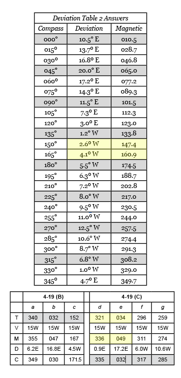
86. |
Bearing in part D of 4-9 should read 070M. |
86 and 87 |
See corrected answers below.
|
| 88. | 5-15 (c) answer refers to "use trig or..." this should be "plot the vectors or..." We do not use trig at all in this course. |
89. |
Exercise 6.2 Answer: From a point about 0.2 nmi north of VK the bearing to Cadboro Pt light is 266T, variation is 20E, so the magnetic danger bearing is 246 M. As long as bearing is less than that you will not get set down into the rocks. So "no more than 246 M. |
| 89. | Hs used in the equation is the sextant height or sextant angle measured directly from the sextant. This abbreviation is not used in the text, so we need this clarification. The distance off D = 1 nmi x (target height H in feet / 100) / Hs (in degrees). Or in words, D = H/Hs, where H is the target height expressed in hundreds of feet and Hs is the angular height in degrees. |
| 91. | Solution of 8-5. This should reference the official height of tide table. It should also reference the technique outlined in the text in Figure 8-11. Here is the start of that method. |
| 93. | Exercise 8-14 answers are missing the slack waters: 0517, 1357, 2051. |
| 94. | Answer to 9-1. Original answer had a typo, but more important the currents on the last leg were solved using just one station, whereas it was halfway between two stations. Here is discussion of that: WP1 to WP2 is 1.7 nmi on course 260 T. Leaving WP1 at 1000 and assuming we make good 3.0 we would be at WP2 at 1034. The half way time where we need the current is 1017. The nearest station to the midpoint is1941. Correcting for daylight time and the #1941 corrections we have 0511 PDT @1.45E and slack at 1042. The current as 1017 is about 0.1 kts toward 210. This does not call for correction. The main data are from Rosario with PDT values of 0634 2.9 E, 1042 S, 1340 1.7 F. WP2 to WP3 is 2.4 nmi on course 285T. Leaving WP2 at 1034 we get to WP3 @ 3.0 kts at 1121. The halfway time is 1058. The nearest station is #1961 and corrected currents there are 1150 slack and 1430 1.36 F. The current at 1058 is just a few tenths in direction 015T. No correction required. WP3 to WP4 is 1.6 nmi on course 275 to 280, for N or S of the Light. Leaving WP3 at 1121 @3.0 kts, we get to WP4 at 1152. The midpoint time is 1137. We have a current station on either side of the leg, she can average them #1951 and #1956. We will call the slack before flood correction is (19+3)/2 = + 11m and flood at the midpoint is (31+14)/2 = +23m @ x (1.0+1.4)/2 = 1.2 So we have actual currents at leg 3 midpoint of 1053 Slack and 1403 2.0 F (ie 1.7 x 1.2), and we want to know the current at 1137. We can interpolate this various ways, the answer is 0.73 kts in direction 055. To make good a course of 280 in a current of 0.71 to 055 with a boat speed of 3.0 we must steer in direction of 270.4 and we will make good along 280 at a speed of 2.46 kts. Note we are steering about 10° into the current. Using our shortcut for this bow current, we would estimate (0.71/3) x 40 = 9.5° |
95. |
Answer to 9-2 (B). Current drift is 2.0 not 1.65. Course to steer to make good 000T is 025T = 005 M. SMG = 3.6 kts. |
| 99. | Answer to 12-3. Part A (b) natural range; Part B (c) depth contour Answer to 12-14. (E) False. Offset from pure log-and-compass DR due to current depends only on the time in the current and the current itself. (F) True. Leeway offset depends on our heading relative to the wind direction. |
| Answers | There is an answer to question 3-15, but there is no question 3-15. We are looking for that question. |