

| The Gulf Stream, located along the eastern coast of the United States, is a fast, intense current known as a western-boundary current. These currents are located on the western side of every ocean basin. The Gulf Stream is a result of the wind pattern acting on most of the North Atlantic Ocean. The combination of the Trade Winds (10°- 25°N) blowing to the west and the Westerlies (35°- 55°N) blowing to the east cause the North Atlantic to rotate clockwise. Because of the Earth's rotation, the poleward flow in the western Atlantic is constrained to a narrow current on the western boundary of the ocean basin. This is the Gulf Stream. While western boundary currents exist in all the major ocean basins, the two in the Northern Hemisphere (including the Kuroshio Current in the Pacific) are better developed and more intense than their Southern Hemisphere counterparts. | ||||||||||||||||||||||||
|
||||||||||||||||||||||||
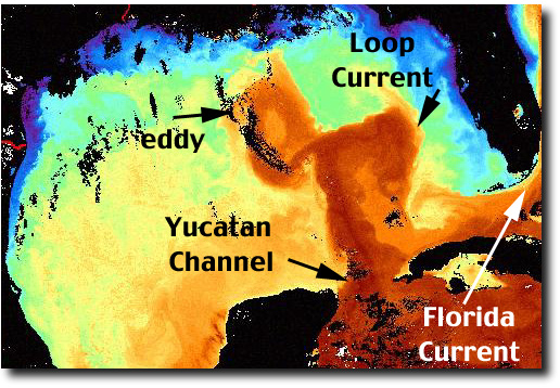
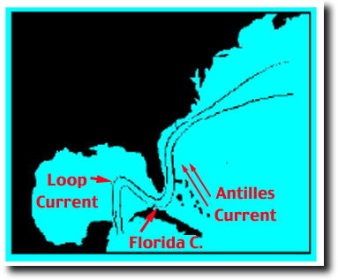
| Under the trade winds the broad, slow North Equatorial Current flows to the west. As the current approaches the Caribbean Sea, water is funneled through the many channels of the Antilles and Caribbean Islands, and through the Yucatan Channel - where it narrows and gains strength - and then loops into the Gulf of Mexico. This is where we can first observe an organized flow on satellite images. This flow enters the Gulf of Mexico at the Yucatan Channel and exits the Gulf at the Straits of Florida. The current is commonly referred to as the Loop Current while it's in the Gulf of Mexico and the Florida Current when it leaves the Gulf between Florida and Cuba. | ||||||||||||||||||||||||
|
|
||||||||||||||||||||||||
|
||||||||||||||||||||||||
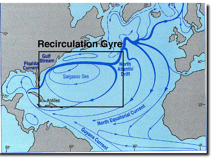
| Along the east coast of Florida the current is fed by the Antilles Current, and the flow, now called the Gulf Stream, runs parallel to the coast until reaching Cape Hatteras where it leaves the coast and enters deeper water. At approximately 50°W, the Gulf Stream splits into several currents the largest being the North Atlantic Current. The North Atlantic Current then feeds both the Norwegian Current which transports water northward along the west coast of Europe and the Canary Current which flows equatorward on the eastern side of the Atlantic. | ||||||||||||||||||||||||
| The transport of the Florida Current is approximately 30 Sverdrups (Sv). One Sverdrup is one million cubic meters of water per second! The transport of the Gulf Stream increases to 85 Sv near Cape Hatteras, peaks at 150 Sv near 65°W, then decreases eastward of 65°W. |
||||||||||||||||||||||||
| One of the primary reasons that the Gulf Stream increases in transport between Florida and 65°W and decreases in transport downstream of 65°W is the Recirculation Gyre. As the figure below shows, water leaves the Gulf Stream downstream of 65°W, and enters the Sargasso Sea. This water is recirculated clockwise throughout the Sargasso and eventually re-enters the Gulf Stream. This flow is known as the Recirculation gyre. | ||||||||||||||||||||||||
|
||||||||||||||||||||||||
|
||||||||||||||||||||||||
| BACK | NEXT | |||||||||||||||||||||||
|
||||||||||||||||||||||||