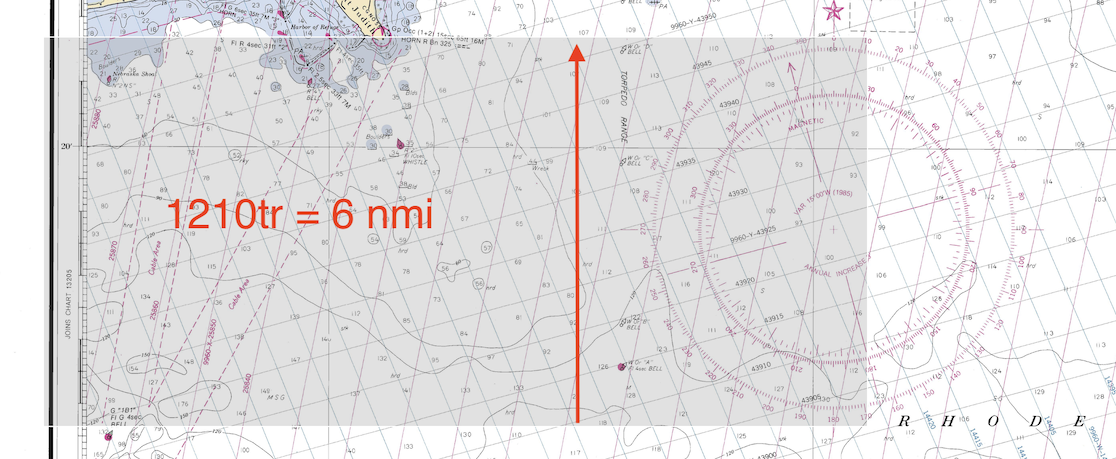
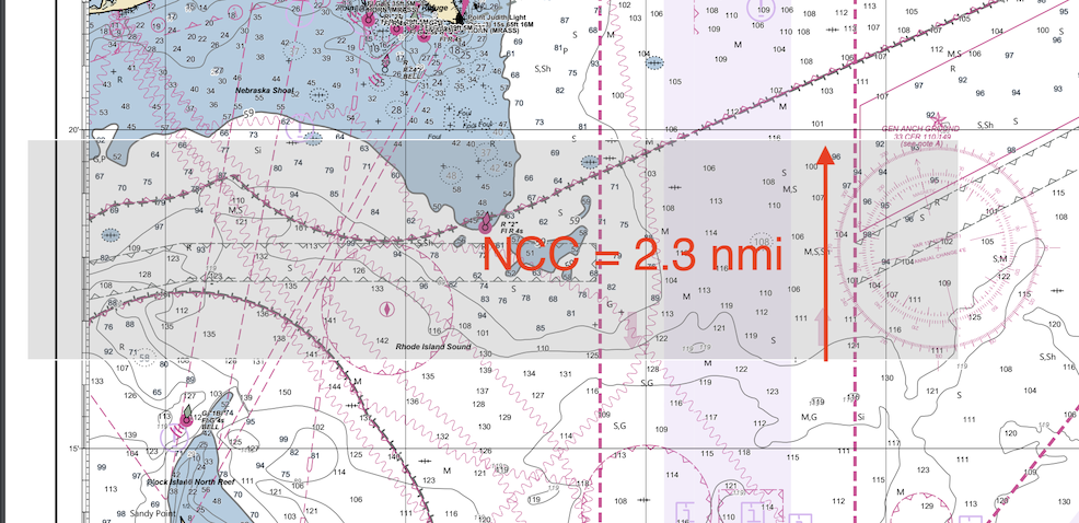
— According to multiple tests so far, compass roses should be notably bigger. See graphic examples from 1210tr paper vs NCC below.
— No need to print the larger regional magnetic variation ENC symbols as they have no counterpart on paper. Just print the smaller point magvar symbols and values. The larger regional symbol serves no purpose.
— Recommend consider shutting off depth contour labels as it adds to clutter in many cases, and contour values are easily figured and annotated manually as needed. There is still a label crashing issue and if contours are near the labels, it just make it worse.
• Contour labels are still misleading, in that they do not represent the actual contour, 12 ft is listed as 11, 18 as 17, and so on. Maybe best to just not show them?
• On the other hand... unlike real NOAA ENC, we can on the NCC app zoom in to see what depth contours are there and choose them to get a match for shallow, safety, and deep contours. On real ENC we have to ask for a value just below the compilation values, else it will be skipped to deeper one for reasons explained in our textbook.
• Hence, maybe best to have the option to show/hide contour labels… or maybe fixing the crashing of labels may sort this out in later versions.
— * * * Need to print MHW value on every chart or in the notes. I cannot find it on the NCC chart; needs to be there. A standard part of every traditional paper chart. This can be read from the ENC as negative of DRVAL1 of any foreshore DEPARE. Needed to figure bridge clearance, light and islet heights. Maybe I am missing this somewhere?
— Can end up with blank spots on the chart in some cases when positioned extent covers an area with no chart coverage. Even with careful positioning we might get blank sections depending on the overlap of reschemed and legacy ENC. Shift the location a bit to find a solution... or add the next highest scale band to the set, but this can lead to more crashed labels. Needs experimentation. Often there is no info in the blank areas so they can just be left.
— For a first pass at NCC with no personal catalog defined, we need to first "create chart" in the Chart Setting tab before we can create a catalog. After that we can just open the catalog we created.
— Chart notes are not always complete (ie on 18765 Note X and S are missing), plus regional notes have no identification on the chart, ie, you can know there is military practice somewhere on the chart, but we do not know where. This info is in the ENC and could be marked in later versions of the app. One solution is study the underlying ENC and then make personal notes on the notes locations.
— Still an ongoing issue of label overlaps. User may need extra charts at higher scales to see details.
— It seems we cannot add a compass rose to a 1:10,000 chart on smaller paper sizes. We are still looking into this.
— Lights on beacons that show up as tear drops (flashes) on NCC do not show the associated daymark that could be with them. This is likely a remnant of their NOAA choice to show the old TCP symbols on NCC rather than the standard ENC symbols.
— One thing we miss in the NCC is the lack of low-accuracy indicators on hazard symbols. The information is programmed into the ENC (as QUAPOS attributes) that the printed NCC are based upon, but NCC app V3 does not print them. These can important annotations, being the ENC equivalent of the "PA" (position approximate) or "PD" (position doubtful) labels that were very common on paper charts.
— We should stress the value of having a copy of the free Mac or PC app qtVlm to use in preparing your NCC. With it you can load the same ENC you are basing the NCC on, and this way identify chart note sources, read labels that may be crunched in the NCC and also see other features that might be missing, such as the PA or PD indicators.