|
Author
|
Topic: Good Fix without a DR?
|
Nathaniel
|
 posted July 21, 2015 11:38 AM


All the exercises in the book, that are non LAN require a Dr-lat/Dr-lon & running fix procedure, but is there any way of getting a good fix in the open ocean if you lost them? The reason why I'm asking is I'd like to apply celestial navigation to the desert & I was wondering If I was stranded out in the middle of nowhere with no coordinates, if it was possible to get a good fix just by using the stars/planets?
From: Sweden
|
|
David Burch
|
posted July 21, 2015 12:14 PM
You can use any nearby position for the assumed position and end up with an accurate fix.
One good exercise is take sights from the mid pacific (ie get the results from www.starpath.com/usno) then assume you are in NYC, and just carry out the normal procedures. you will get large a-values, then just make a small scale chart to plot them, then use that fix as the DR to reduce them again.
In a couple iterations you will find your right position.
In short, however, you will always have some coordinates... and they will indeed be much closer than NYC.
Put another way, unless you are unconscious for a long time in a fast moving vessel, you will always know where you are to within a few hundred miles.
For example, think of a town that is somewhere about 100 miles from you now, and ask yourself what you would have to do, and for how long, to not know if you were in that town or where you are now.
From: Starpath, Seattle, WA
|
|
Tom Quinn
|
posted June 11, 2026 02:58 PM
I know this is an older topic. I am a little lost in the reply and I had the same question too. If I were kidnapped by my wife and she dumped me in the desert.....how would I get a DR Lat and Lon.
The last sentence, think of a town.... I would use a map to get a Lat and Long of a close city? or if I didn't have a map because she said sorry, and oops. I could just memorize a city's (like NY) lat and Lon?
The "what you would have to do and for how long somewhat throws me"?
Thank you
Tom
From: Chicago
|
|
David Burch
|
posted June 11, 2026 03:16 PM
Very surprised that i did not mention our Emergency Navigation book in the 2015 answer! That is a large part of the subject matter of that book. See: https://www.starpath.com/catalog/books/1830.htm
If you just need a DR for cel nav, but have all the other tools needed (ie accurate UTC, sextant, almanac, SR tables), then this is fairly trivial.
In NH, the height of Polaris gets your latitude, within a few tenths of minute if you do not know your DR, likewise a noon sight for Lat does not really require any DR.
To get Lon, you need the correct time, then you do a series of sights around noon so you can find the time of LAN, and then look up the GHA of the sun at that time, which is your Lon.
These methods work in the desert and in the arctic. If you do not have a reasonable horizon, you can use an artificial horizon, which is indeed how explorers in both desert, arctic, and jungle did do it.
Also more generally, you do not need an accurate DR for a fix. You can just assume your Lat = 0 and Lon = 0 and do the sight reduction in the normal way. You will get huge a-values, but just plot them out and use the (incorrect) fix you get as your DR, and do the sight reduction again. It might take 3 iterations, but then you find out where you really are. It is a good exercise to work out one of the fixes in the book starting with that DR.
From: Starpath, Seattle, WA
|
|
David Burch
|
posted June 11, 2026 03:47 PM
Let me pursue this a bit more, to emphasize that you do not need any DR at all in principle for celestial fix.
A sight gives us Ho, and 90-Ho is z, the zenith distance, which is the distance between us and the GP. We are located somewhere on that circle of position of radius z with center at the GP.
The GP is located at GHA and dec at the time of the sight. Thus we have for each sight we take, of any body, Ho, dec, and GHA.
With two sights we have two such circles and we are located at one of the two intersections of those two circles of position.
You are not necessarily going to do a fix this way, but if you wanted to, you could. Go to our online app at
https://www.starpath.com/calc/van_allen2.html
Enter that data and compute the two intersections, one of which is your fix.
It is always easy to determine which is right. The air temperature alone might do it, as they could be far apart! Even different hemispheres. Or just recall which direction you were looking when you did either of the sights, and then picture looking in that direction from each of the solutions.
From: Starpath, Seattle, WA
|
|
Tom Quinn
|
posted June 11, 2026 03:48 PM
LOL, My wife is looking at me crosseyed as I just purchased three of your books this week. LOLOL. Thank you for the reply!
From: Chicago
|
|
David Burch
|
posted June 11, 2026 04:00 PM
Thanks for that. If questions come up, you can post them here.
From: Starpath, Seattle, WA
|
|
Tom Quinn
|
posted June 11, 2026 07:26 PM
I am doing Sun Sight Exercise #2 (5.4) in the book using DR as 0 degrees N and 0 degrees W. To choose the A-lon within 30' of the DR Lon, and my DR Lon being 0 degrees, my minutes of the GHA is 145 deg 37.6 min. Wouldn't I then choose 359 degrees 37.6 as my A-Lon?
Subtracting the this A-lon from GHA I get -214 degrees 00 W for my LHA. Then adding 360 to get a positive number I am at 146 degrees.
I am not warm and fuzzy about my answer here as I am not finding tab Hc for Lat of 0 degrees with a Dec of 19 degrees N and a LHA of 146....
Being so new...I sense I am totally doing something wrong... Would your emergency book help me out in this position?
From: Chicago
|
|
Tom Quinn
|
posted June 12, 2026 10:55 AM
I did not mean to post a second duplicate question.
I am guessing here my error is in the 0,0 degree and a minute GHA of 37.6. With the "within 30 minutes" for the a-lon, I am guessing here that 359 would not be the correct answer.
This is probably where I am stuck at....
TQ
From: Chicago
|
|
RobertR
|
posted June 12, 2026 11:15 AM
I think some confusion has crept in here between actual navigation procedures, and the thought-experiment of using the St Hilaire method to determine our position without first knowing roughly where in the world we are. Which is an interesting thought experiment, but St Hilaire's entire point was that actual navigators DO know where we are, by dead reckoning if nothing else, so we aren't actually figuring out our location blind.
The "rule" of choosing our aLon within 30' of our DR Lon is intended to give us our best LoP (which is after all a short segment of a small-circle, not a straight line, as we draw it).
But in this thought experiment, we AREN'T within 30' of our AP, or maybe even 1000'. So it's fine to use 0°00' for this first iteration. Once we have our AP down to within a degree or so of reality, we can start caring again about this level of precision.
In the "real world" (presuming that there were any real-world scenario in which a navigator would not know which ocean they were in) we would do better, as David mentioned, to simply plot the GPs of the bodies on a desk-globe and subtract Hs from 90° to derive and plot the circles of equal altitude from them.
|
|
Tom Quinn
|
posted June 12, 2026 11:47 AM
That makes total sense. Thank you
Now for the humor of a possible real world scenario...We knew who really shot JR (Ewing). We were then captured and taken to a large body of water somewhere. It was a many hour flight so we don't know E or W of North America if even there.
We were then blindfolded and placed into a dingy an towed somewhere. They forgot about the Davis Mark 3 lifeboat sextant and in this box was a nautical calculator and universal plotting sheets. There were also some breath mints but that probably doesn't fit into the equation.
The dingy had a very shoddy tow rope and it broke. The scoundrels never did realize the dingy was gone. I worked my blindfold off but had no clue where I was at....Immediately commenced was the use of the sextant.....
Hence our problem.....where am I and how do I row home?
Also another side note, they loaded the boat with all the White Castles I could hope to imagine, and lemonade, so the dingy had some ballast. Food and water was not an issue.
From: Chicago
|
|
|
|
Tom Quinn
|
posted June 13, 2026 01:55 PM
I am doing Sun Sight Exercise #2 (5.4) in the book using DR as 0 degrees N and 0 degrees W. I know I will have to do multiple iterations and I know this is thought experiment and math experiment only and not really real world.
I am having difficulty with the first iteration and the LHA. Is there a Nav calculator that I can plug in the data and form 104 can be completed as a way to check my work to not bother you all?
Also, with the first iteration, my LHA is 145 degrees. Trying to find the Data of box 5 seems to me to not be possible. The Tab (Hc) is not listed on the charts of pub 249.
I am trying to work through to get the large A value but I keep hitting stumbling blocks...
Thank you
Tom
From: Chicago
|
|
RobertR
|
posted June 13, 2026 07:50 PM
I have to recommend letting go of this bone until you have actually completed the homestudy course.
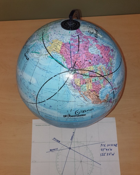
For purpose of demonstrating that you can find your rough location from three raw sextant sights, refer to the photo here. Simply plot the GP of the body onto a globe, then subtract your Hs from 90°, and draw the difference (Zenith Distance) as a circle around the GP. You are somewhere on that circle.
Shoot and plot to more bodies the same way, where the three circles cross is your fix. Or at least, a suitable AP from which to begin your standard sight reduction.
|
|
Tom Quinn
|
posted June 13, 2026 08:02 PM
Per your recommendation, I will let go of this. I feel a little defeated but I will probably return to it upon completion of the course.
Thank you
Tom
From: Chicago
|
|
RobertR
|
posted June 13, 2026 08:31 PM
As far as iterating the fix from any random location on the globe.
Your GHA is 145°, so your LHA from 0° Longitude is also 145°. Common sense suggests, and pub 249 confirms, that this is well below the horizon. Your Hs was 58°, so you aren't more than 32° (1,920 nm) away from the GP.
So a possible first iteration could be, "I must be in the the same part of the world as the GP of the body." So you could choose an aLon of 145°W. With an aLat of 0° and a declination of 19°N, that would mean the object was due north of you.
But it wasn't; we know from the rest of the "normal" problem (and would know on the boat from looking at our compass) that the object was southwest of us. Which means that we must be northeast of the GP, by about 2,000 nautical miles, or 32°. So that's two or three iterations before we even begin to do math, and simple plotting of that on a Mercator projection chart yielded an AP about 220 nm east of my actual position. Which I could plot on a universal plotting sheet in its native scale without further iteration, but I would probably recalculate and reiterate one more time.
Once again, these techniques and the thought processes behind them will make much more sense to you once you have worked through this entire homestudy course, and also the Emergency Navigation homestudy course.
Master routine navigation first, then the "fancier" things will make much more sense.
|
|
Tom Quinn
|
posted June 13, 2026 08:36 PM
I also understand about the three fixes and the intersection of the three circles. That makes sense. Thank you for the reference photo too.
It seems I have asked too many questions here on a topic I had just learned about in Chapter 5, or so I thought. I apologize and will refrain from asking any more questions in these forums and thus bring an end to this topic.
Sincere Apologies
Tom Quinn
From: Chicago
|
|
RobertR
|
posted June 13, 2026 08:49 PM
No worries, we're here to answer questions, as best we are able. But I do think you will benefit from working through the basics of the course first. With practice, a lot of these "new" concepts will become very intuitive.
The elegance of the Marcq St Hilaire method of sight reduction (which is the foundation of most of this course, and most "modern" celestial navigation) is that we DON'T need to find our position from anywhere on the globe. As competent navigators, of course we know roughly where we are; we just want to know even more precisely.
A century and a half ago, this idea was paradigm-breaking. In the hundred and fifty years since, we have yet to surpass it for routine navigation with a sextant and chronometer.
|
|
RobertR
|
posted June 13, 2026 08:56 PM
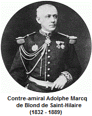
Admiral Marcq St Hilaire.
|
|
|
|
David Burch
|
posted June 17, 2026 08:48 AM
I need to apologize about my suggestion of using 0,0 as a DR for any sight. That was too extreme, because, for example, working out Star #3 and Star #4 fix using 0,0 DR you soon learn that the stars were not over the horizon from there, so the St Hilaire method does not work.
This fix (44º 39.0'N, 122º 12.5'W) is from somewhere in NW Oregon using artificial horizon.
So as an exercise, choose your DR to be Cabo San Lucas, Mexico (23N, 110W). A quick check shows this converges to the right answer in about 2 or 3 iterations, depending on how you are plotting the large initial a-values.
The first plot gives very large a-values, but then we use that fix for the DR of the second sight reduction, get a new DR, and use it for a fix, etc.
In short, you do not need to know where you are to find out where you are from cel nav, but you do need to know what ocean you are in! and you can't test this with just one LOP, it has to be done with a fix.
Or for a more dramatic demonstration that you do not need a DR at all, use the Van Allen Solution mentioned above.
From: Starpath, Seattle, WA
|
|
|


