|
Author
|
Topic: Exercise5.7 a-Lat for a-value
|
Brad
|
 posted December 15, 2011 04:17 AM


Greetings!
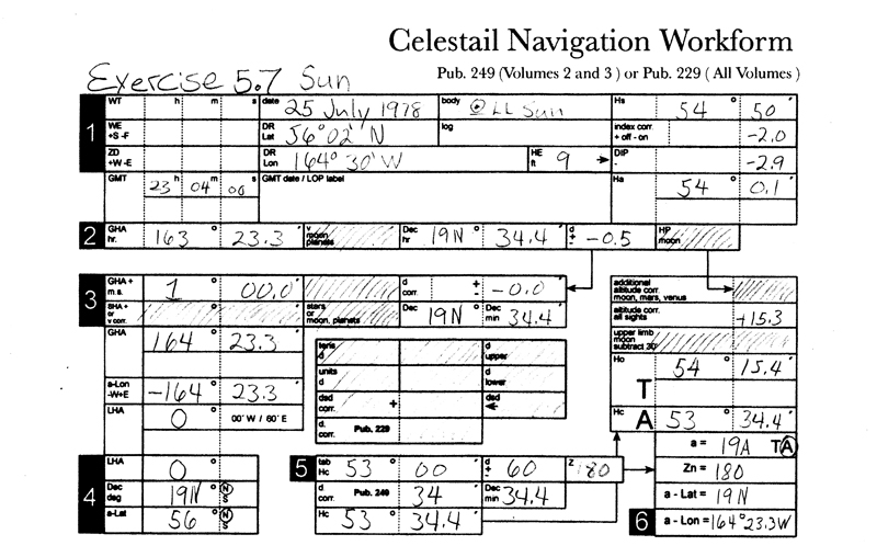
I seem to be having a problem in understanding the way in which you derive the answers to Exercise 5.7 #1,2,3
I have completed the site reduction as instructed but cannot figure out what is meant by Adjusting the a-Lat for the a-value from page 72 to arrive at: 41°.0 T 180° 55° 19.0 .
Is there someone that may have a visual explanation to this question? I used to think I had rather good reading comprehension but I guess in my older age I am having to resort to the (Follow The Dots) method.
I have included an example of my work.
Thank you!
Brad Summers
From: Los Angeles
|
|
David Burch
|
posted December 15, 2011 05:04 PM
Please keep in mind these are very special exercises... not really part of a routine operation. their job is to remind us that there is nothing special about an LAN sight for lat. It is just another LOP that happens to be parallel to the bottom of the chart.
we show this by doing a routine sight reduction of a an LAN Hs value. in doing this, you will choose an assumed lat (ALat) and you end up with an a-value and a Zn.
the Zn should be very close to 180 when looking south to the noon sun or 360 looking north.
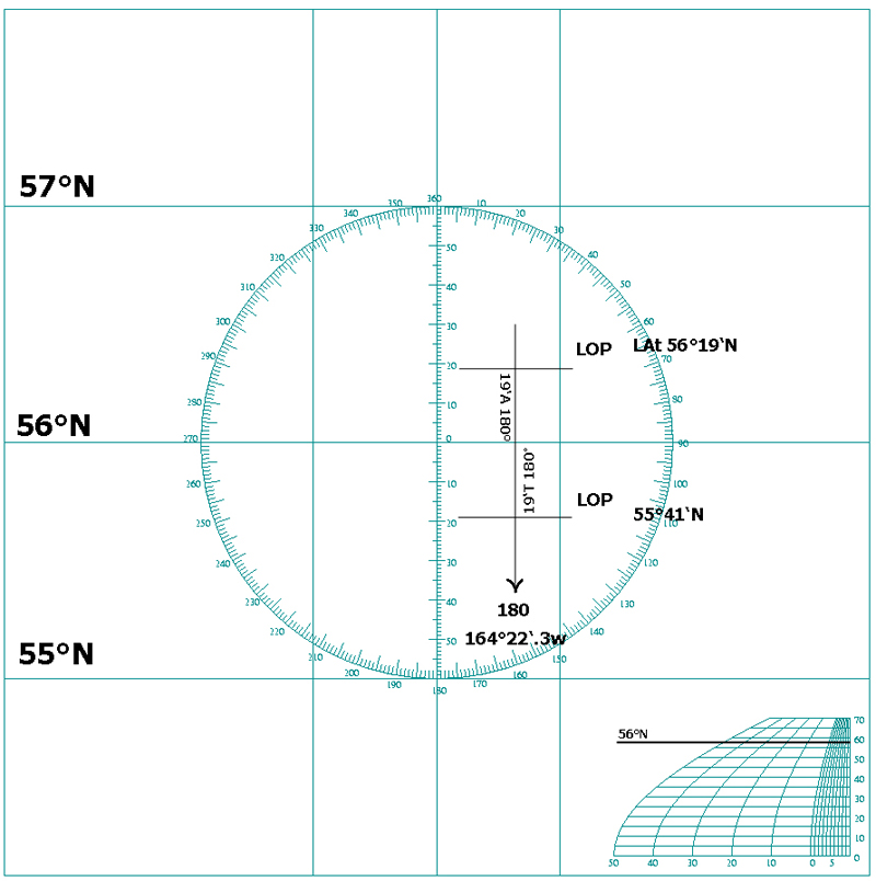
then suppose you used aLat = 34 N (looking south) and you got a = 20.0 T 180. then "correcting for aLat would mean, either plot the LOP and read off the lat you found, or you can do this without plotting, namely 34° 00' - 20' = 33° 40' N
does that clarify the issue?
From: Starpath, Seattle, WA
|
|
David Burch
|
posted December 15, 2011 05:59 PM
forgot your example. you used 56 N and got 19' A from 180 which means lat is 56° 19' N.
if the rest of the form is correct, that would be your lat as found from a regular sight reduction of a sight taken precisely at LAN.
note in box 6 the lat is not recorded properly. that should be 56 N, not 19N
From: Starpath, Seattle, WA
|
|
Brad
|
posted December 15, 2011 08:24 PM
Thanks for your help and also pointing out my error in recording the Lat in box 6
Brad
From: Los Angeles
|
|
Brad
|
posted December 16, 2011 06:02 AM
I understand the concept that you have demonstrated, Quote then suppose you used aLat = 34 N (looking south) and you got a = 20.0 T 180. then "correcting for aLat would mean, either plot the LOP and read off the lat you found, or you can do this without plotting, namely 34° 00' - 20' = 33° 40' N
My Question!
So then why is the answer in the book for Exercise 5.7-1 on pg184: 55°19.0N?? Should it not be 55°41.0N??
56° 00 -19 = 55°41.0 N
Thanks,
Brad
From: Los Angeles
|
|
David Burch
|
posted December 16, 2011 05:42 PM
i made the assumption that the rest of the form was correct (i did not check it). as it turns out, it is not correct. The Hs should be 5' not 50'. Then compare with the answers in the book (table at the bottom of page 185)to get a = 41.0'T 180, and final lat = 55 19.0 N.
It is just an unfortunate coincidence that several errors ended up with the right answer when figured from the wrong form data... which shows at 19.0'T a value from a wrong lat.
best to start from scratch on this one.
From: Starpath, Seattle, WA
|
|
arguin
|
posted January 18, 2012 04:55 PM
I was curious what program was used to create the plotting sheet.
|
|
David Burch
|
posted January 18, 2012 05:00 PM
We usually use Adobe Illustrator for such work. There is an open source counter part called inkscape
http://inkscape.org/
quite nice and free, whereas Illustrator is very expensive.
From: Starpath, Seattle, WA
|
|
|


