|
Author
|
Topic: Help with reading longitude from plotting chart
|
Galileo
|
 posted September 02, 2014 09:41 AM


Hi,
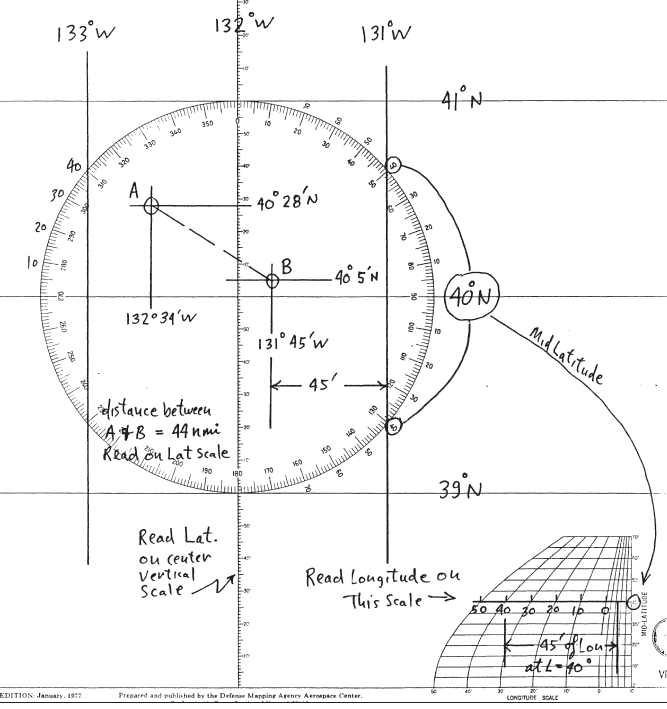
I am able to read latitude from the universal plotting sheet figure 4.2.1, but I need help reading the longitude off the small scale in the bottom right. I can't figure out where to read data.
Thanks,
Patrick
|
|
David Burch
|
posted September 02, 2014 09:45 AM
Draw a horizontal line across the diagram at a place on the diagram equal to the mid lat of the sheet you are using. then the length of that line is 60' of Lon at that mid Lat, which is used for the full sheet.
From: Starpath, Seattle, WA
|
|
David Burch
|
posted September 02, 2014 09:52 AM
From: Starpath, Seattle, WA
|
|
Galileo
|
posted September 03, 2014 06:05 AM
Your answer merely reiterates (almost word for word)just what is in the text book...actually with an identical diagram.
I can read. But I still cannot understand your explanation.
Please provide another diagram and some additional verbiage. ie. use other words to describe, or I would prefer a call to discuss. 646-523-6916.
|
|
David Burch
|
posted September 03, 2014 10:16 AM
I just noticed that you are signed up for the cel nav course.
In the instructions to the course it explains that if so, it is best to post your questions in the Student discussion forum.
Please post your question in that forum and perhaps you can add a note on what part of the UPS set up instructions that is not clear to you and we will elaborate on it... or if needed we will make a video showing the set up procedure, but our first goal would be to try to clarify or re-write the instructions if not clear.
thanks
PS... we do have a new diagram of this which we will post there when we see your question.
From: Starpath, Seattle, WA
|
|
Galileo
|
posted September 06, 2014 06:43 AM
How do I enter the student discussion forum?
My question:
How do you take the information regarding the position on the plotting sheet and transfer it down to the small chart in the bottom right?
Thank you.
|
|
David Burch
|
posted September 20, 2014 03:26 PM
Sorry, we missed this post. Since you have access, the student forum is best. That forum is monitored by at least 3 instructors every day. This one no so often.
Here is that link (must be logged in to get there)
http://www.starpath.com/cgi-bin/ubb/ultimatebb.cgi?ubb=forum;f=4
...but i worry why this is not clear, as it is marked in the online classroom several places. Please call the school at your convenience and we can double check that you are in the right place online.
the short answer (probably too short) is you use dividers to move the spacing down from the chart (ie position to nearest meridian) to the nomogram for arc minutes of longitude.
From: Starpath, Seattle, WA
|
|
|


