|
Author
|
Topic: Starpilot
|
pphillips
|
 posted April 21, 2023 05:31 AM


Is there a trigonometrist in the house? Having gotten so far in the course as to suspect that accuracy in plotting lies in the eye of the beholder, I bought a used Starpilot calculator and set off from Florida, on a ship bound for Rome.
Equipped with a Davis Mk 15 sextant, I assiduously practised taking sights. My first running fix put me in the Mackenzie River delta. Sights taken west of the Straits yesterday went as follows: April 20, DR 36 degrees 07' N, by 008 degrees 43' East.
Time GMT 17:17:00; IC 1.41 off, HE 50 feet, HS 33 degrees 52'. Result: Azimuth of 278.3 degrees, A-value of 1539.6 miles toward. That put me in the Madeiras. Changing HE made little difference, the a-values are wildly wrong. I now suspect the calculator spent too long on the former owner's microwave. Longitude and IC are positive. This might be as far as I trespass into Celestial Navigation if no fix for this problem.
|
|
David Burch
|
posted April 21, 2023 08:00 AM
May I first say that the StarPilot is remarkably dependable. If it runs at all, it is almost certainly right. New, or used for 15 years, that would be true.
As for the data presented, it looks like the input of the sextant height... or some other value is not right.
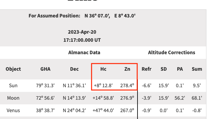
Below from www.starpath.com/usno shows that if the position and time are right, then the height should be more like 8º
Can you please double check all of your inputs. it is unlikely that the actual sextant value could be off that much.
From: Starpath, Seattle, WA
|
|
David Burch
|
posted April 21, 2023 08:06 AM
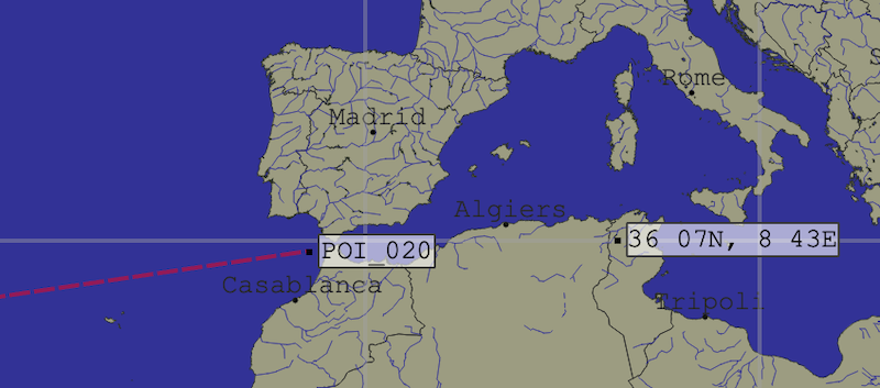
Maybe start with the DR position. The image shows the GC route FL to Gibraltar, but your DR seems to be in Tunsia
From: Starpath, Seattle, WA
|
|
David Burch
|
posted April 21, 2023 09:23 AM
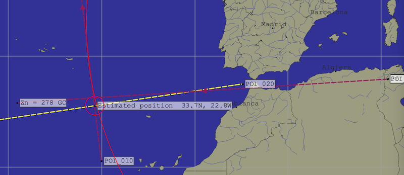
Since the StarPilot does indeed compute the right values. we can use what you report for the a-value to find out where you likely were. So here i plot the incorrect DR position and then extend out the computed a-value and draw the LOP and assume your ;location will be about where that LOP crosses the direct route to Gibraltar. as shown here.
then we get an estimated position. then in the next post we can see what sextant height that would get.
From: Starpath, Seattle, WA
|
|
David Burch
|
posted April 21, 2023 09:26 AM
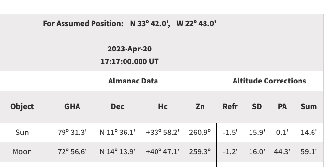
Now from that estimated position we go back to the USNO site to get what you should have measured, and indeed within all reasonable errors this is what yu observed.
ie you measured 33 52 and we get here 33 58
The main message is, a key goal in cel nav is to learn to check and doublecheck all of the work before drawing conclusions.
From: Starpath, Seattle, WA
|
|
David Burch
|
posted April 21, 2023 09:27 AM
PS. i just realized this is all in the public discussion forum, and since you are in the cel nav course, the best place is to discuss such details is there. We will move this topic to that forum and we can continue discussion there. Thanks.
From: Starpath, Seattle, WA
|
|
|


