|
Author
|
Topic: Query about question 2-14
|
Robert Grigsby
|
 posted November 19, 2004 10:01 AM


I am doing Section 2 according to your course syllabus. I have read chapter 4 and am doing the questions from lesson 2. I am having difficulty with question 2-14. Course = 075M from Spit buoy R "2". Radar range 4.5nm to N tip of Protection I. with a 45R Brg. I went to the Northern tip of Protection I. and placed a compass point and then scribed an arc with a 4.5nm radius. I added 75M (boat course) to 45M Relative to get 120M. Took reciprocal of 120M which is 300M and drew an LOP from the Northern tip of Protection I. at 300M and where it crossed the arc I assumed was my EP. My answer was 48deg., 10.25'N & 123deg., 01.6'W with a depth of 44 fathoms which is wrong(both position & depth). Where am I going wrong? Where in Chapters 1 through 4 is the discussion on radar ranges & bearings? I am afraid to proceed without this knowledge as the next questions pertain to radar ranges and bearings.
Thank you,
Sincerely,
Bob Grigsby
|
|
David Burch
|
posted November 19, 2004 01:53 PM
Hi Bob, i think a picture might work for problem 2-14, as it seems you are doing this right as you describe it. I cannot account for the difference unless there is a plotting error somewhere...
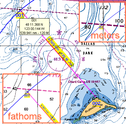
My copy of the answers has depth = 52 fathoms, which seems wrong. On the meters chart insert we get about 105 to 109 meters (note contours are every 10 meters, and our position is between two 100-m contours) which is 105*3.28/6 = 57 fathoms to 60 fathoms, and on the fathoms chart insert it looks like about 64 fathoms. So i would guess the depth at 58 to 64 fathoms, with this large uncertainty.
Note i worked this first electronically on a Canadian chart using meters and noted the question about the depth not being very obvious and then loaded a new american chart 18471 under the same drawings and captured the region around the intersection, which is shown in the bottom left above. And when writing this up recalled that we use 18465, so i did it again with that chart to get this:
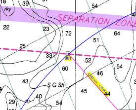
Which again, just stresses that we do not get good depth information from this measurement regardless of what chart we use. In this picture we are between two 50-fathom contours, and can still only guess that the chart implies we are at 60-something fathoms. Note that these 3 different charts of the same spot give rather different depth descriptions in this region.
Another thought... if you have the paper version of our course and would like to practice working these problems electonically asi have done above, then you could purchase our e-chart supplement. That gives a very nice echart program and GPS simulator, as well as 4 electronic charts of this region.
========
Radar is not discussed much in the course book. There is a short section in 6.12. It is covered in great detail in my new book on radar called Radar for Mariners from McGraw Hill. I expect delivery of real books any day now.
With all the information provided, however, this is not specifically a radar problem so much as a general distance off plus bearing problem.
From: Starpath, Seattle, WA
|
|
|