|
Author
|
Topic: Question 7-3
|
Michael Mitgang
|
 posted March 12, 2005 10:35 AM


Please advise how you get 1.9 and 2.4 miles. The depths at those distances are approximately 20 fathoms not 13.
Please show a picture of how/where you are measuring.
Thanks
From: Menlo Park, CA
|
|
David Burch
|
posted March 12, 2005 08:42 PM
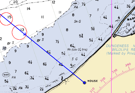
Below is the picture. It is asking for depths along a magentic bearing of 110 M to the house. The printed answers appear to be correct: 13 f is about 1.9 nmi offshore (sounding to shoreline) and 15 f is about 2.4 nmi offshore.
The point in the exercise is to note we need to take draft and tide height into account when navigating by the depth.
From: Starpath, Seattle, WA
|
|
|