|
Author
|
Topic: Light Sectors
|
Dan Cline
|
 posted April 09, 2006 02:35 AM


I was recently looking at a chart that showed lights with multiple colored sectors. For example, one light located near a narrow channel between islands had, going clockwise, an approx. 120 deg green sector, then an approx 5 deg white sector, then an approx 90 deg red sector, then an approx 90 deg green sector, then an approx. 5 deg white sector, then an approx 50 deg red sector.
Is there a system that explains this complex group of colored sectors?
Dan
From: Midland, MI
|
|
David Burch
|
posted April 10, 2006 10:16 PM
Sector lights are used around the world, with perhaps a larger emphasis in some European waters. They are single lights that show a different color depending on where you are when you view them. These could be sweeping lights that change colors as they rotating beam passes new filters, or they could be mulitbulb lights that are separated by blinders to only show in specigic regions.
These lights are discussed in our Inland and Coastal Navigation course book and in the Chart Trainer software program. Below is a sample from a Swedish chart. The sector symbols are convenitional ECDIS style, which differs some from the US charts.
Often there are actual radial lines extending from the chart showing where the colors change, but if there is any doubt, you should check the List List which will state specifically where the colors change.
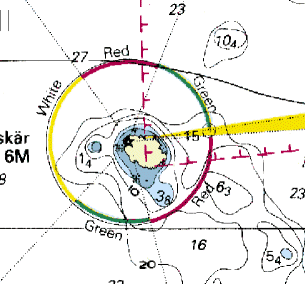
It is important to remember that the specified bearing range that defines a color sector is as "seen from seaward," looking toward the light. So for the same below we get these range limits:
Green from 345 to 042
White from 042 to 144
Red from 144 to 202
Green from 202 to 262
White from 262 to 266 -- this marks a range at 264
Red from 266 to 345
Print out this graphic and use a protractor to see how these angles are defined.
Generally a look at the chart will show why the sectors are as they are. Generally they mark a hazard from some perspective, or in this case also a range line along a channel. We will get some more of these and a better picture later on.
From: Starpath, Seattle, WA
|
|
David Burch
|
posted April 11, 2006 09:31 AM
Here is another example from the west caost of Vancouver island, just at the entrance to the Str. of Juan deFuca.
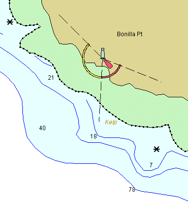
Here is what the vector chart data had available on this light with a right click:
Lighthouse
Aid number: G5289
Shown 1/6-7/12
Sector Light:
FlR 4.0s 56ft 8M 292.0°-3.0°
FlW 4.0s 56ft 8M 3.0°-135.0°
We have to forgive them for writing 3.0° when they should have written 003.0°. This is a commercial version of vcector charts. I would hope the official ECDIS had this right.
Below is the NOAA chart symbol.
We leave it up to the reader to find in the Canadian Light List (online) the description of this light and to post it here. Maybe that will state what the sector marks. It looks like it marks the corner of Cape Flattery! and the mid channel buoy "JA" of the VTS system.
In other words, if you were traveling west along the Canadian coast and wanted to head south offshore, and it was foggy, you should not turn left while that light is still red.
We look forward to the Canadian LL description of this light.
From: Starpath, Seattle, WA
|
|
Dan Cline
|
posted April 11, 2006 06:37 PM
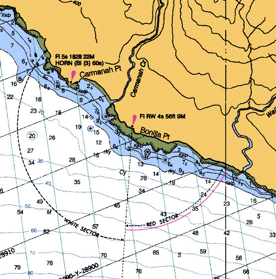
Here is the description from the Canadian Light list. The red sector lies east of a line from Bonilla Point to Tatoosh Island:
Number:
180.5
G5289
Name:
Bonilla Point
Fisheries
Position, Lat N, Long W:
On point.
48 35 43.8
124 43 04.1
Light Characteristics:
Fl W-R 4s
Focal Height in m. above water:
17.0
Nominal Range:
8
Description:
Orange tripod skeleton
tower, red triangular
slatwork daymark.
Remarks/Fog Signals:
Fl R to the E. of line between
Bonilla Point and Tatoosh Island;
Fl W to the W.
Fisheries light shown from June 1
to December 7 (approx.) each
year.
Seasonal.
Chart:3606
From: Midland, MI
|
|
David Burch
|
posted April 12, 2006 02:46 PM
thanks for that. so we see the sector light is essentially marking a line of position for entering or leaving the point-to-point entrance to the Strait. Often the sectors are used to mark hazards, but this does not seem to be so in this case.
prior to about 1998, the tatoosh island light had a red sector marking the two rocks called Duncan and Duntz, but this sector marking has since been discontinued... i went immediately for that example and then discovered it was gone.... it was always a rather weak demarcation, meaning you saw both colors for some distance, so maybe it was decided that this was less safe than not having any at all?
From: Starpath, Seattle, WA
|
|
|

 Topic Closed


