|
Author
|
Topic: Celestial Navigation book Exercise 4.5 E
|
JohnL
|
 posted December 01, 2018 11:35 AM


I believe there may be an error in the "E" part of the subject exercise. I got all the other part answers to agree with the book answers (within about .2 to .5 minutes) using the same plotting method as for part "E". I have checked that the input you used for your calculator matches what I used from the book and I have plotted this part 3 times coming up with the same results. I have included a plotting sheet PDF. The answer given in the book and from your calculator is just off the page to the left (West) so that is what brought me to this conclusion. Please evaluate this graphically.
From: North Carolina
|
|
|
|
David Burch
|
posted December 01, 2018 01:07 PM
Just thought of something else we can do after seeing your plot. We can make a high res solution to these plots and then have it on the support page. In fact, at one point we had these all plotted, and it was included in the book, i think for the main reason to show they will all fit on one sheet as i recall.... if that recollection is correct, then anything off the page is indeed inconsistent.
From: Starpath, Seattle, WA
|
|
David Burch
|
posted December 01, 2018 02:46 PM
Hello again John
Steve just plotted this out and got
on a UPS and got 35° 25.5' N, 146° 45.5' W... with double checking
which is off of the StarPath LOP Checker which gives 35° 24.7' N, 146° 48.5' W.
Is this the level of discrepancy you are talking about? If so we have to track down this 3' of Lon. That is too large a difference between plot and compute. One is not right.
What are you getting for a fix?
From: Starpath, Seattle, WA
|
|
|
|
JohnL
|
posted December 02, 2018 10:19 AM
OK I compacted and cropped my plot as much as possible and included it in this reply. I hope that it was not so diminished that the pertinent information was lost or obscured. I am trying to answer all the replies at once so forgive me if I missed some point.
First the Lat is probably close enough 35 degrees 25.x minutes N in all the solutions. Its the Lon that is in question 146 degrees 4x.x minutes. The original solution in the book was 48.5 minutes (as you and I pointed out) is off the plot. Your reply plot came up with 45.5 minutes, and my plot came up with 41.6. There is a fair amount of discrepancy among these results (about four to seven miles). So, in jest, here we are wondering where that landfall is. Maybe if we climb to the top of the mast?
From: North Carolina
|
|
David Burch
|
posted December 02, 2018 11:27 AM
Can you check the width of the meridian spacing. At 35º this should be 49.1 nmi. Your pic looks like 38.5 nmi.
From: Starpath, Seattle, WA
|
|
JohnL
|
posted December 02, 2018 02:46 PM
David,
I shrunk everything to get the graphic down in size for the posting restrictions. So the plot and the Lon scale are most likely not of correct or even related size. I did my plots on one of your plotting sheets as I did for all the parts for the exercise. The "E" part is the only one that did not come close to your book answer. I remember the statement in the book about being very concerned about doing accurate plotting and took it to heart as I am a newbie at this.
Just a thought, perhaps nobody ever got to the last part of the exercise after getting a bunch of the parts correct. However, the incompatibility with your computer calculations would have a far more troubling reason. I have written a good deal of logic programming in my career and not much arithmetic programming but as I recall from my college days floating point calculation can have certain "rounding" type errors associated with a haphazard order of applying arithmetic operation. Yet this possibility does not sit well with the fact that only part "E" and only the Lon is in question.
From: North Carolina
|
|
David Burch
|
posted December 02, 2018 07:35 PM
To help us find a plotting error we need a picture that is not distorted.
Pictures can be reduced in size without distorting them. Try another picture and reduce to 800px across without distorting the image, and then post that one. If you use a Mac you can do the reduction with Preview. If a PC, then you can use MS Paint.
Or maybe we can answer without a picture. On your plot, how many nautical miles are there between 145W and 146W?
PS. did you see the video I posted above that plots this one out using OpenCPN electronic plotting tools?
From: Starpath, Seattle, WA
|
|
JohnL
|
posted December 02, 2018 10:04 PM
I did not get a chance to view the video yet. I'll take a look. For this post I just shrunk the whole plot by 30% to keep the scale. I don't know what distortion might be introduced by Paint but there it is. BTW I did look at the scale and on my plot at Lat 35 degrees 1 degree Lon was, as you said, 49.1 nmi.
Perhaps I have taken too much of your time with this concern. I am comfortable that I understand the plotting procedure. I would be willing to just move on. I will leave this decisions up to you if you want to understand.
From: North Carolina
|
|
JohnL
|
posted December 02, 2018 10:10 PM
Oddly the plot in my last post does not look as it did in Paint.
From: North Carolina
|
|
David Burch
|
posted December 02, 2018 10:27 PM
On LOP 10 (starting at lon 146 08), the a value is 34.0' But it looks like this one is plotted at just under 28' Can you please check that.
From: Starpath, Seattle, WA
|
|
David Burch
|
posted December 02, 2018 10:39 PM
In passing, it looks like a picture changed... as i do not see the distorted one any longer. It was sideways to these and the compass rose could be seen as distorted.
Did you change a picture from an earlier post? I did not think that was possible in our system. Maybe you posted one with the identical name?
From: Starpath, Seattle, WA
|
|
JohnL
|
posted December 03, 2018 08:39 AM
Yes, I posted all the files with the same name. It looks like your system keeps the file name and just a link to the file (to save disk space I assume, smart). So when I posted the last cropped file all post pictures were updated. This also explains why my in last 2 posts (one a repeat because I though I posted a wrong file) all looked the same and wrong. I guess the updates are not real time but a batch process so until the posting process was complete the pictures did not change.
Anyway I checked the "a" on my plot and the jpeg. They seem to be 34' of Lon not of Lat. There in lies my error. The "a" value is in nmi actually even though it shows up in the book work sheet excerpt as minutes (a bit confusing). I seemed to have only make this error on the "E" part probably because I did this plot after some time away. However, I did notice that 34 minutes goes off my plotting sheet and that may be why I made the error.
Sorry for troubling you with this.
From: North Carolina
|
|
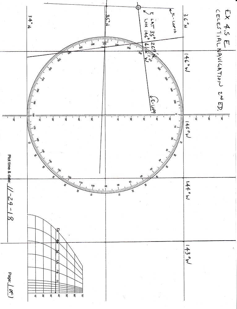
JohnL
|
posted December 03, 2018 09:35 AM
OK, I plotted part "E" again but moved the center meridian to 146 degrees W so as to stay on the paper. As you can see I got an answer close to the book answer as I did on the other parts. Again sorry for the trouble.

From: North Carolina
|
|


