|
Author
|
Topic: Prob. 1-11 part b "Inshore zones"
|
Sandy Englehart
|
 posted December 12, 2004 12:38 PM


i can't figure out what the inshore zone is and how to measure it.
|
|
David Burch
|
posted December 12, 2004 02:08 PM
This is an important concept in the application of the Navigation Rules. We cover it in most detail in our product called Nav Rules Trainer.
The following is from that product:
inshore traffic zone
Vessel Traffic Systems divide water ways up into several zones. There are the two main traffic lanes, outbound and inbound, a separation zone between them, and the two so-called inshore zones, which are the water ways between the main traffic lanes and the shorelines. They are marked with the green lines in this sketch.
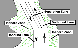
In the Puget Sound traffic system, the lanes are about 1 mile wide, and the inshore zones vary from several miles wide to much less than a mile wide, usually narrowest at points of land.
Regions in US waters that use traffic zones are itemized with full details in the appendix to the navigation rules in Table 26.03(f): Vessel Traffic Services (VTS) Call signs, Designated Frequencies, and Monitoring Areas
Traffic lanes are always shown on nautical charts, but the "inshore zone" is not definedwe must know what it means from our course work!
From: Starpath, Seattle, WA
|
|
|