|
Author
|
Topic: Charleston Channel day beacon
|
David Burch
|
 posted June 21, 2011 03:20 PM


Greetings Starpath helpdesk!
I've attached an image file of an unidentified day beacon located in the
Charleston Channel (Coos Bay Oregon). It's a diamond shaped sign with
four quadrants, two are black aligned vertically and two white diamonds
aligned horizontally.
I've tried to find it (and it's purpose) in NOAA's Chart One. No luck.
A US Power Squadron books lists a similar looking sign with a vague
description meaning "you are here". Possibly a marine survey sign?
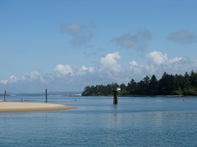
Does anyone in the Starpath community anyone know what it's purpose is?
Best regards,
Tom
From: Starpath, Seattle, WA
|
|
David Burch
|
posted June 22, 2011 11:31 AM
This is a type NB day board with no lateral significance. It is marking some hazard or point of reference, which most often must be identified by finding the mark on the chart.
Such marks are referenced in the Chart No.1, but best reference is the front end of any USCG Light List. Here is a copy of those pages on buoys and day marks from the Light List.
From: Starpath, Seattle, WA
|
|
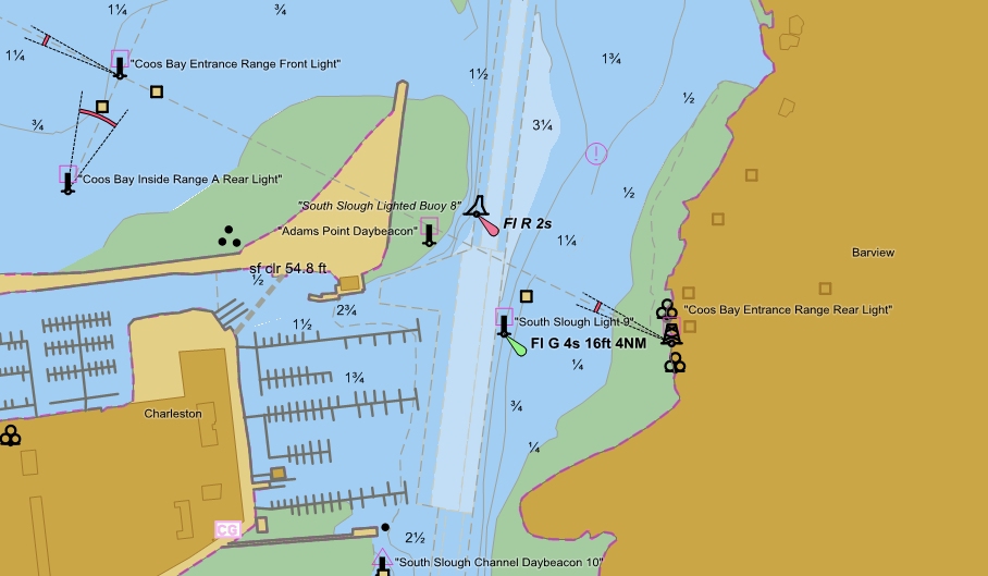
David Burch
|
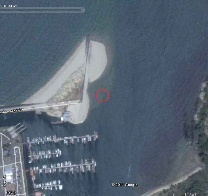
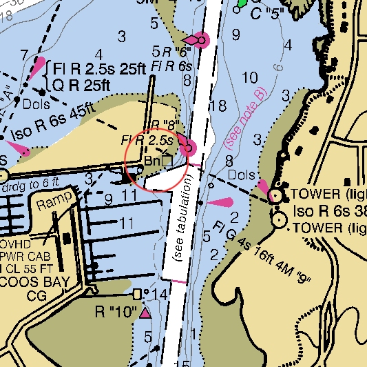
posted June 22, 2011 12:05 PM
Here is what it looks like on the chart and on Google Earth. It seems to be marking the boundary of the shoaling. Note that the chart does not show much, so having a feature such as given by memory map navigator that lets you see the google earth image is very useful.
From: Starpath, Seattle, WA
|
|
David Burch
|
posted June 22, 2011 01:19 PM
Thanks for this question, because it also shows a very important point, namely we can sometimes get more information from the vector charts (ENC) than we can with the RNC supplemented by the Coast Pilot. Recall that the job of the coast pilot is to include important nav info that is not on the chart, so we need to look up this in the coast pilot to see what they say about this mark.
In the meantime we learn a lot from the RNC, shown below.
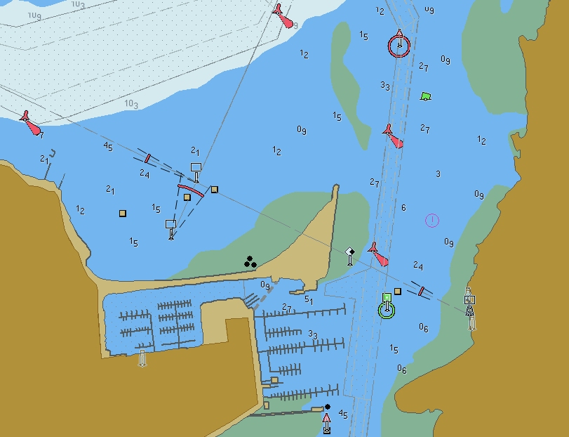
This is the official S-57 chart from NOAA, which has the information layers we need to learn about this aid to navigation.
With ENC charts, you get the information about a buoy or daymark by right clicking it. i will do that now with this one and then post the info below, which does indeed tell us all about this marker.
You can do this yourself, exactly as i am doing using the free opencpn.org viewer and then downloading the free ENC which is ENC chart number US5OR47M
you can find a list that correlates RNC numbers (paper charts) to the ENC at this link:
http://www.charts.noaa.gov/ENCs/ENCsIndv.shtml
From: Starpath, Seattle, WA
|
|
David Burch
|
posted June 22, 2011 01:27 PM
When you right click the daymark in question on the S-57 echart, it brings up a list of the categories of information, namely
Depth area
Caution area
Navigation system of marks
Navigation line
Daymark
Beacon, special purpose/general
each of these can then be clicked to read
Depth area
Feature Class: DEPARE
Attributes
DRVAL1 -1.8(m)
DRVAL2 0.0(m)
Caution area
Feature Class: CTNARE
Attributes
INFORM (COLREGS Demarcation Line.
Refer to Code of Federal
Regulations section 80.1320)
SCAMIN (500000)
TXTDSC (US002381.TXT)
Navigation system of marks
Feature Class: M_NSYS
Attributes
MARSYS IALA B(2)
Navigation line
Feature Class: NAVLNE
Attributes
CATNAV leading line bearing a
recommended track(3)
ORIENT 116.0(Deg.)
SCAMIN (260000)
Daymark
Feature Class: DAYMAR
Position: 043 20.8562 N 124 19.2241 W
Attributes
COLOUR white white black white(1
1 2 1)
COLPAT border stripes squared(6 4)
NATCON painted wooden(9 6)
TOPSHP rhombus (diamond)(12)
SCAMIN (90000)
Beacon, special purpose/general
Feature Class: BCNSPP
Position: 043 20.8562 N 124 19.2241 W
Attributes
BCNSHP pile beacon(5)
CATSPM general warning mark(27)
COLOUR Unknown
OBJNAM (Adams Point Daybeacon)
STATUS permanent(1)
SCAMIN (90000)
==============================
in short, we know all about this now, including its name and various purposes. it is not only marking a danger it is part of a range line, but we will have to study the chart to understand that.
From: Starpath, Seattle, WA
|
|
David Burch
|
posted June 22, 2011 01:29 PM
Somewhere we have lists of all of the S-57 abbreviations, class definitions, etc. I will try to find these and post them.
again, thanks for bringing up this question. All questions lead to useful discussion.
From: Starpath, Seattle, WA
|
|
David Burch
|
posted June 22, 2011 01:38 PM
Note that in one note they refer to colregs demarcation lines, and one might get the implication that this marker is related to that, but it is not. that is just telling you which rules apply in the location of the marker.
see back of the Nav Rules book to learn the boundary for colregs is
§ 80.1320 Coos Bay, OR. A line drawn across the seaward extremities of the Coos Bay Entrance Jetties.
From: Starpath, Seattle, WA
|
|
David Burch
|
posted June 22, 2011 01:52 PM
Another view, this is from Coastal Explorer, which also shows S-57 charts, but in a different format, which is not strictly ECDIS, but a style they feel is better.
Notice we can now see clearly that this mystery marker not only marks the shoaling, but it is also on range with the main entrance range to Coos Bay at 116T. This means that when you cross this line between this day mark and the rear range marker you have an LOP.
From: Starpath, Seattle, WA
|
|
David Burch
|
posted June 22, 2011 03:26 PM
This topic has now been moved to the Student Discussion group for further details from us on this.
We will follow up there on details of using the various S-57 readers to get these data.
Remember you can get to the NOAA chart download section for ENC and RNC from
www.starpath.com/getcharts
From: Starpath, Seattle, WA
|
|
|