|
Author
|
Topic: Going 'paperless' with weather maps (radio fax)
|
John Almberg
|
 posted March 06, 2019 10:57 AM


I find weather maps (surface charts, 500 mb charts, etc.) vital while at sea. I have been printing them out, since I find it easy to compare two or more charts by laying them side-by-side. But printing is problematical at sea. My portable printer isn't fastened down, and it is just another power drain on my limited battery power.
Since the images end up on my iPad, one way or the other, I would like to go paperless and just view the charts on the screen, but I find this is much less convenient than printed copies, mainly because it is so awkward to compare various maps, like two surface charts, or a surface chart and a 500 mb chart.
I could use my laptop for this, but the iPad is handier, the images are on it, and it uses less power.
Has anyone found any software that facilitates the study of various weather maps?
Thanks, in advance.
From: St. Augustine, FL
|
|
David Burch
|
posted March 06, 2019 11:54 AM
Hi John,
You are definitely doing the right thing by comparing products. Doing this digitally is definitely easier in a computer than in an ipad. Proposals depend on mac or pc. Which kind of laptop do you have, Mac or PC?
We have recently published a note on how to transfer files on the boat wirelessly. This would be a key tool to using both. There are two parts to it:
http://davidburchnavigation.blogspot.com/2019/02/moving-files-around-on-iphone-and -ipad.html
and
http://davidburchnavigation.blogspot.com/2019/02/how-to-wirelessly-transfer-files- among.html
Once this is set up, you can just drag and drop files to share with all devices.
As for a tool to compare images, there are two choices, either side by side, or full images switched back and forth... or you can overlay them and apply some transparency.
On the other hand.... OpenCPN (Mac or PC, no iOS) has a powerful plugin that lets you automatically download most of the weather images you might want automatically and then it automatically georeferences them. With that you can compare GRIB data overlaid on the image, or you can indeed load two images and switch relative transparencies.
I believe we have a video on the process or maybe more at www.starpath.com/videos in the opencpn playlist.
If you have a specific example of products you want to compare then list them here and we can demo how to do it that way and others.
again, the other tools depend on mac vs pc.
From: Starpath, Seattle, WA
|
|
|
|
John Almberg
|
posted March 08, 2019 07:57 AM
I have a MacBook so it is easy to transfer the images using AirDrop. The problem is much smaller on a laptop, but the iPad has two advantages: it's easier to curl up in our pilot berth with it, and it uses a bit less energy - something we have to ration at sea.
I haven't found much help on the Internet on this topic, so I've been doing a lot of digging for apps that might do the trick.
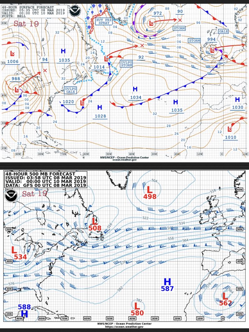
I have found one interesting iPad app called TwinViewer. If you put the day's charts into Photos, TwinViewer can access those photos, and you can swipe through them independently on both halfs of the screen, lining up any two photos you want to compare.
I also like to write the day and local time at the top of charts -- a tip I believe I got from MODERN MARINE WEATHER -- which you can also do with an app. I've been trying out Snap Markup.
Examples attached.
From: St. Augustine, FL
|
|
David Burch
|
posted March 08, 2019 09:41 AM
I see what your goal is (use a tablet), and i will look into this. But first a couple points.
even with mac and air drop you need to have on the boat at sea the network. that is covered in our videos. if you do not have irigium go or a router like sidekick or optimizer you can use the $20 Hootoo. In fact, this little router is so powerful i would consider it mandatory equipment for a modern offshore vessel.
looking at your example of comparing 48h surface forecast and 48 500 mb, i will make a video to show two ways you can compare these with just a couple clicks.
back as soon as i can get to this. one is on a computer, but again, the tools on a computer are orders of magnitude advanced compared to tablets. If device size is an issue, then a macbook air is extremely small and light and the microsoft surface pro is as well.... but you notice i did not mention budget! these are both expensive devices. the other method is using grib files where we just add the two files and display at the same time. this can be done on tablet or computer.
In passing, Luckgrib (Mac or iOS) now has a service for getting grib files (highly compressed) offshore by email request. this is the state of the art grib viewer and state of the art source of grib data.
From: Starpath, Seattle, WA
|
|
|