|
Author
|
Topic: From Sydney to Hawaii
|
Mark Davis
|
 posted April 20, 2003 05:57 AM


The year is 1812 and you are in Sydney. You have a boat but no navigational equipment. A ships captain gives you an old chart so that you know the positions of Sydney and Hawaii. Your aim is to hit Hawaii. How do you do it? You have only your chart and your knowledge, and maybe a year to make astronomical observations. I would be interested to hear ideas on this navigational problem.
|
|
David Burch
|
posted April 20, 2003 04:17 PM
Hi Mark, very nice question. Before we dive into this from here, i will ask our ongoing online cel nav class to have a shot at it, but we are still a bit early in the course for this. Some may want to start already, however, with a hint to re-read lecture 1 with this in mind.
thanks again.
-david
From: Starpath, Seattle, WA
|
|
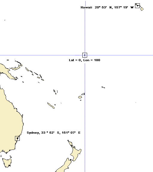
David Burch
|
posted April 29, 2003 10:00 PM
Here is a picture to help the perspective. Note that Hawaii is 54° 53' north of Sydney, known from chart alone.
From: Starpath, Seattle, WA
|
|
David Burch
|
posted April 29, 2003 10:14 PM
Let us also clarify the question. If Mark checks back in here, he can confirm or correct these assumptions.
We assume that "no navigation equipment" means no sextant and no star almanac (although both were available in 1812). From our own lesson one, we know we can get there by zenith passage, but we need a star that passes over Hawaii.
So let us reword the question, to how will we determine from Sydney a star that passes over Hawaii knowing only its latitude?
Note too, we are allowed "observations," so this must mean that though we do not have nav equipment to take with us, we are free to build whatever type of observatory we need on land to measure accurate star heights.... this is in fact not difficult at all... a 10-foot quadrant would do the job for this quite nicely, and it is easy to orient it precisely North on land.
OK that is all we add for now... what must the navigator do to find his zenith star?
Note that that person in Sydney might not know at all about the North Star, so we can rule that out immediately?
For those who have the Emergency Navigation book (see books catalog), you might also check the section on latitude by meridian passage of circumpolar stars on their lower transit. This method can be easier and more accurate than zenith passage.
--david
From: Starpath, Seattle, WA
|
|
Mark Davis
|
posted May 31, 2003 01:00 AM
Let's assume that the navigator has a watch but that it is not accurate and doesn't keep a constant rate. The navigator doesn't have an almanac or tables but has 12 months to make any celestial observations he wishes and can make any sort of instrument he wishes. He has a chart which shows ocean currents as they were known at the time. Let's also assume that a friendly sea Captain gives our navigator a 3 hour lecture on navigation so that he understands the basics.
Thanks,
Mark
|
|
|