| • With a bluetooth GPS in view of a portlight, you can check your course and speed, find the next waypoint, range and bearing to a landmark, or tweak your route... all while sitting anywhere on the boat.
• Wonder how things are going in the middle of the night, when all tucked in behind a lee cloth in an upper bunk? Reach under your pillow, push a button, check it out, and go back to sleep!
• Or take a complete navigation system with you in your pocket when you sail with others or charter a boat on your own, or take a luxury cruise liner vacation.
• Ideal for kayakers or any small vessel not rigged for full-size electronic navigation
• Use it when hiking around the anchorage, or going to town, or for car trips anywhere. Now you can have a full featured electronic system in the palm of your hand, no matter where you are.
• An excellent backup to even the most sophisticated big boat navigation systems.
• Use any version of raster navigation charts (RNC), including the BBS format of the official US echarts. All US charts are now public domain and can be downloaded at no charge and installed in the PC version for use there or for transferring to the ultra mobile device using Memory-Map Navigator.
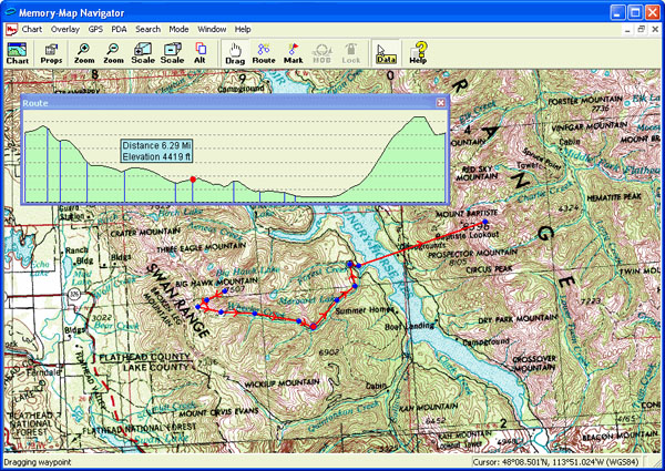
• Or get fancier. Use any scanned image for a chart, or topo maps, aerial charts, captures from online map programs, or sections of a pilot chart (see below). The PC version allows for easy geo-referencing of any image, then edit the size or selection you want and transfer it to the mobile device.
• There are several convenient waterproof cases for the hardware, so you can actually navigate on deck, or call the next tack or gibe on a yacht race right on the dime... even if you are getting set a lot in current.
• There are unlimited applications to ultra mobile navigation, and there is no other software program available for hand held devices that offer the mariner so many features.
• The authors of the software offer professional support for operation in your device of choice. .
Memory-Map's high performance "QuickChart" scrolling and zooming algorithms give the user interface a snappy, responsive feel you won't find on other navigation packages. Powerful new features in the chart management and route/waypoint editing system, and large toolbar buttons make Memory-Map Navigator easy to use when you are at sea or on the move.
|