||
Return to StarPilot Page ||
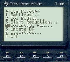
StarPilot Fix by USNO Method
This method is described in detail — some would say gruesome detail — at the back of the Nautical Almanac, which is produced by the US Naval Observatory in collaboration with the British Admiralty. StarPilot executes this procedure exactly as they outline it.
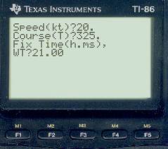
At the beginning of each fix, StarPilot will ask for the course and speed that applied during the sights, and ask for a sight time. If you have not already entered one, it will also ask for a DR position.
The computed Lat and Lon of the fix is then displayed along with the distance from the DR to the fix position. This latter distance is important to record as it is an important measure of the accuracy of your DR. If this distance is more than 20 miles, you will be prompted to press the [ENTER] key, which will re-compute the fix using the previous fix position as the new DR position, and again report the new fix position and the new distance from DR to fix. When the DR is rather wrong to begin with, this correction or iteration can make a significant difference in the final fix. This iterative process, by the way, is no different than normal procedure when doing the fix analysis by hand from plotted LOPs.
The 1999 Nautical Almanac example
July 4, 1999 DR position at 21:00 UT is 32° 00' N, 15° 00' W. Course is 325T and speed is 20 kt. At this approximate time, the following three sights were taken. The sights were given as Ho values at UT, so we have added 1.9', 2.0', and 0.9' respectively to put the refraction back into the Hs values. Then use HE = 0 and IC =0 and you can test these with your own methods calling the values Hs. [Needless to say, sextant sights are never accurate to the 0.01' stated here, nor is celestial navigation itself accurate to that level, but this is the way the example was presented, presumably to provide test cases for the numerical procedures, which is just what we are doing here.] The actual process for entering the data in StarPilot can be seen in the Sight Reduction sample page.
| Star |
Time (UT) |
Hs |
Intercept and Azimuth |
| Regulus (#26) |
20h 39m 23s |
27° 15.90' |
a = 2.2' A 267.3 |
| Antares (#42) |
20h 45m 47s |
25° 59.22' |
a = 22.9' T 151.7 |
| Kochab (#40) |
21h 10m 34s |
47° 28.88' |
a = 21.1' A 359.0 |
From these
the Nautical Almanac gives the fix at |
31° 37.1' N, 15° 01.2' W. |
|
| The StarPilot USNO method yields |
31° 37.1 ' N, 15° 01.3 ' W. |
|
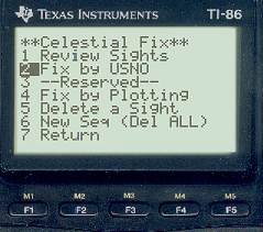
The following screen captures show how this is done with StarPilot. Generally you would first do a Review Sights check to see that you have stored what you want.
All fixes first ask for speed, course, and fix time.
 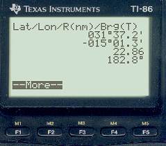
Output on the right shows Lat/Lon of fix plus range and bearing from DR position to Fix position, in this case 22.86 nautical miles in the direction of 182.8 True. Since this is more than 20 miles, StarPilot will recompute the fix from a new DR equal to the fix position just found.
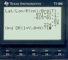
In this case there was very little difference in the final answer. However, if the original DR was more than 100 miles off or so, you will see a mile or so improvement in the final iteration. Note that it is naturually the first range and bearing from DR to fix that is important to note for your records, ie to see how good your DR was, but it is always the last computation of the position fix that is the most accruate and should be stored.
In the next step we will say yes and update the DR and then go to the Plot routine to see where this fix is located relative to the LOPs. These LOPs are shown plotted by StarPilot in the Fix by Plotting example.
||
Return to StarPilot Page ||
|